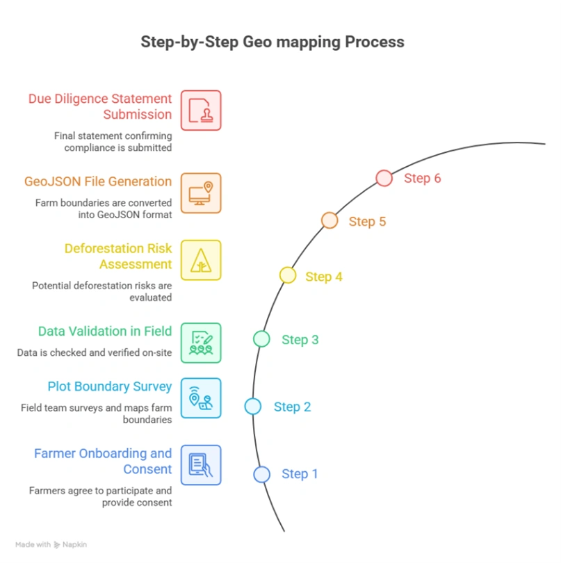
Quick summary: Regulation (EU) 2023/1115 commonly called EUDR applies directly to coffee, one of Tanzania’s key agricultural exports. Entering into force on June 29, 2023, with compliance deadlines starting December 30, 2024, the regulation identifies coffee as one of seven commodities linked to deforestation risk, alongside cattle, cocoa, palm oil, rubber, soya, and wood. Geo mapping for […]
Regulation (EU) 2023/1115 commonly called EUDR applies directly to coffee, one of Tanzania’s key agricultural exports. Entering into force on June 29, 2023, with compliance deadlines starting December 30, 2024, the regulation identifies coffee as one of seven commodities linked to deforestation risk, alongside cattle, cocoa, palm oil, rubber, soya, and wood. Geo mapping for coffee exporters in Tanzania is becoming a critical capability, enabling accurate data capture, validation, and compliance at scale. This guide walks through each element of that process.
EUDR Deadlines Are Near
Start your free trial before your coffee exports are blocked.
What the EU Deforestation Regulation Requires for Coffee Exporters
Core Legal Obligations
Operators and traders placing coffee or coffee-derived products on the EU market must demonstrate three essential conditions before any shipment is accepted:
No deforestation: The coffee must not originate from land that was deforested or degraded after December 31, 2020. This is especially important in Tanzania, where coffee is cultivated in regions like Kilimanjaro, Arusha, Mbeya, and Ruvuma, often near forested areas.
Legal compliance: Production must comply with all relevant national laws in Tanzania, including land-use rights, environmental regulations, and labor standards.
Due diligence: A due diligence statement must be completed and submitted through the EU information system, confirming that risks have been assessed and mitigated across the supply chain.
The Geolocation Mandate
Article 9 of EUDR makes geolocation mandatory for coffee supply chains. Because coffee is a land-based commodity, exporters must provide precise geographic data for every plot where coffee is grown.
Key data requirements include:
GPS polygon mapping: Exact boundary coordinates of each coffee farm must be captured as polygons (not just single GPS points), accurately outlining the production area.
Plot-level traceability: Each mapped plot must be uniquely linked to the coffee being exported, ensuring full traceability from farm to shipment.
Coordinate accuracy: Geolocation data must meet strict accuracy thresholds, typically within a few meters, requiring reliable GPS-enabled devices or satellite-based tools.
Timestamped production data: Coordinates must correspond to the actual production period to confirm compliance with the December 31, 2020 deforestation cutoff.
Data submission format: All geolocation data must be uploaded into the EU’s due diligence system in the required standardized format.
For Tanzania’s coffee sector characterized by smallholder farmers organized through cooperatives and production spread across multiple highland regions building scalable geo-mapping capabilities is essential. Accurate GPS polygon data collection, validation, and integration into traceability systems will form the foundation of EUDR compliance and ensure continued access to the EU market.
Coordinate type
GPS polygons (lat/long pairs forming a closed boundary)
Accuracy standard
Parcel-level, sufficient to verify against satellite forest-cover data
Cut-off date
December 31, 2020 (forest cover must be intact at this date)
Format requirement
GeoJSON or compatible geospatial format
Linked documentation
Due diligence statement referencing coordinates
Submission system
EU TRACES / dedicated EUDR IT platform
Tanzania Coffee Exports
Tanzania’s coffee exports are on a steady upward path, with 2025/26 export volume forecast at 1.37 million bags and production at 1.45 million bags, supported by better farming practices, rehabilitation of aging plantations, and stronger Robusta output. Export earnings have also improved sharply in recent years, rising from US$161.2 million in 2022 to US$227.9 million in 2023, and one 2024 estimate places coffee export value at about US$239 million.
Data Snapshot
In 2024/25, Tanzania’s green bean exports were about 1.25 million bags, and the 2025/26 forecast rises to 1.36 million bags, while total coffee exports are projected at 1.37 million bags. The European Union remains the biggest destination, taking 652,901 bags in 2024, far ahead of the U.S., while Japan was the second-largest market with 200,254 bags. Tanzania’s coffee sector is still highly smallholder-based, with roughly 320,000 farmers and most plots averaging less than one hectare.
Indicator
Time Period
Value / Quantity
Coffee Export Value
2023
US$227.9 Million
Coffee Export Value
2024 (Estimate)
US$239.0 Million
EU Coffee Imports from Tanzania
2024
652,901 Bags*
Green Bean Exports
MY 2024/25
1.25 Million Bags*
Coffee Export Volume (Forecast)
MY 2025/26
1.37 Million Bags*
Coffee Production (Forecast)
MY 2025/26
1.45 Million Bags*
Market Insights
Robusta is the main growth driver, especially in Kagera, where land expansion and subsidized seedlings are boosting supply. Arabica still matters because it supports Tanzania’s premium reputation, but Robusta is increasingly important for export growth and total volume expansion. The sector is also benefiting from strong global prices, which have lifted export revenues faster than physical output in some periods
The key trend is that Tanzania is growing through a mix of rehabilitation, yield recovery, and Robusta expansion rather than through large-scale plantation farming. That makes the country attractive for buyers seeking diversified East African supply, but it also means performance depends heavily on smallholder productivity and older tree replacement. The export mix is still heavily Europe-focused, so compliance with EU traceability and deforestation rules is becoming more important for long-term market access.
Tanzania matters because it combines premium Arabica origins with a rising Robusta base, giving it flexibility in both specialty and mainstream markets. For exporters, the biggest opportunity is to improve quality consistency and traceability so the country can capture more value from its coffee rather than exporting mostly unprocessed green beans. For buyers, Tanzania offers stable supply potential, but the supply chain remains fragmented and highly dependent on smallholders.
GeoJSON Errors Can Delay EU Shipments
Verify farm boundaries, fix formatting issues, and ensure your data is ready for DDS submission.
Why Geolocation (GPS Polygons) Is Mandatory for Tanzania’s Coffee Supply Chain
Under Regulation (EU) 2023/1115 (EUDR), GPS polygon mapping is not a procedural formality it is the technical foundation that enables verification of deforestation-free coffee. For exporters in Tanzania, where coffee is cultivated across thousands of smallholder farms in highland regions such as Kilimanjaro, Arusha, Mbeya, and Ruvuma, precise geolocation is essential to prove compliance and maintain access to EU markets.
The Satellite Verification Pipeline
EU authorities and third-party verifiers rely on satellite monitoring systems such as the Copernicus Programme, European Space Agency’s Sentinel missions, and Global Forest Watch to detect deforestation at the plot level. This verification process only works when exact farm boundaries are provided.
The verification logic for Tanzania’s coffee supply chain operates as follows:
Step 1 — Exporter submits GPS polygon coordinates for each coffee farm supplying the shipment.
Step 2 — Coordinates are overlaid onto historical satellite imagery dating back to December 31, 2020.
Step 3 — Forest cover analysis determines whether the land was forested on or before the cutoff date.
Step 4 — Change detection algorithms identify any deforestation events within the polygon after the cutoff.
Step 5 — Compliance decision: If deforestation is detected, the coffee shipment is flagged and may be denied entry into the EU market.
Why Points Are Not Enough
Older traceability systems in Tanzania’s coffee sector sometimes relied on single GPS points (centroids) to represent farms. EUDR explicitly requires polygons instead, for several critical reasons:
Inaccurate representation of farm boundaries: Coffee farms often small, irregular, and intercropped cannot be accurately represented by a single point.
Risk of misclassification: Adjacent plots may differ in compliance status. A centroid could fall on compliant land while parts of the farm overlap forest edges or protected areas.
Incompatibility with satellite analytics: Forest monitoring systems require area-based analysis to measure canopy cover and detect land-use change accurately.
Scalable aggregation: Polygon data enables exporters to aggregate supply from thousands of smallholder farmers and cooperatives while maintaining traceability and auditability.
Regulatory Note
For coffee plots smaller than 4 hectares, EUDR technical guidance allows a minimum of four coordinate pairs forming a closed polygon. Larger plots must reflect the true and accurate shape of farm boundaries.
Using simplified shapes such as square bounding boxes for irregular or smallholder coffee farms is considered non-compliant, as it can misrepresent land use and lead to incorrect deforestation assessments.
Tanzania’s coffee supply chain largely driven by smallholder farmers and cooperative structures faces structural and operational complexities that make EUDR compliance particularly demanding compared to more consolidated coffee systems in countries like Brazil.
Fragmented Smallholder Landscape
A majority of coffee production in Tanzania comes from smallholder farmers, many cultivating plots under 1–3 hectares across regions such as Kilimanjaro, Arusha, Mbeya, and Ruvuma. Key challenges include:
Limited formal land documentation: Many farmers rely on customary or semi-formal land tenure systems, with limited digitized land records.
Highly fragmented plots: Farmers often manage multiple small and dispersed plots, sometimes across different terrains.
Low digital literacy: Adoption of GPS tools and digital systems is limited, requiring trained field teams for mapping.
Cooperative-based aggregation: Coffee is sold through primary societies, cooperatives, and unions, adding layers between farmers and exporters.
Geographic and Infrastructure Barriers
Tanzania’s coffee-growing regions present terrain and infrastructure challenges:
Highland and volcanic terrain: Coffee is often grown in elevated regions, making physical mapping more difficult.
Agroforestry and intercropping systems: Shade trees and mixed cropping can reduce GNSS signal accuracy during mapping.
Remote farm access: Farms are located in rural areas with limited road infrastructure, especially during rainy seasons.
Connectivity limitations: Inconsistent mobile and internet coverage impacts real-time data capture and syncing.
Land boundary ambiguity: Informal or partially documented boundaries can create overlaps during polygon mapping.
Supply Chain Traceability Gaps
Tanzania’s coffee supply chain is cooperative-driven and multi-layered:
Complete the Due Diligence Statement (DDS), referencing relevant HS codes (e.g., 0901 for coffee).
Submit through the EU system (e.g., TRACES NT or the EUDR platform).
Retain all records for at least 5 years, as required under Article 10 of EUDR.
Enabling Scalable Compliance
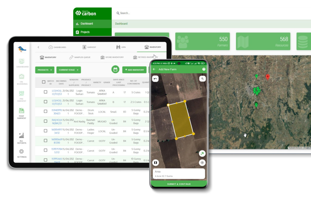
Geo-mapping for coffee exporters in Tanzania can be streamlined through digital platforms that integrate GPS polygon capture, automated validation, satellite verification, and compliance reporting helping exporters meet EUDR requirements while improving transparency and long-term supply chain resilience.
Geo mapping for coffee exporters in Tanzania becomes significantly more efficient with EUDR solutions from TraceX, enabling accurate GPS polygon capture, real-time validation, and end-to-end compliance management across cooperative-driven supply chains.
Common Errors in GeoJSON / Polygon Mapping
Data quality failures at the polygon level are the single most common reason EUDR submissions are flagged for review or rejected. Field teams and data managers should be trained to identify and fix the following errors:
Error Type
Description
Impact
Fix
Self-Intersection
Polygon boundary crosses itself, creating a ‘bowtie’ shape. Occurs when field agent reverses direction while walking.
Latitude and longitude values transposed (lat first, instead of GeoJSON spec’s lon first).
Plot placed in wrong hemisphere or ocean; immediate deforestation false-alarm.
Validate first coordinate: Vietnam lon ≈ 102–109°E; lat ≈ 8–23°N.
Spike Artefacts
One or more vertices are outliers caused by GNSS signal bounce under canopy.
Polygon area inflated; boundary bleeds into adjacent plots.
Remove outlier points; apply Douglas-Peucker simplification at 1m tolerance.
Duplicate Polygons
Same farm submitted twice with different farmer_id due to aggregator duplication.
Inflated area records; compliance review flags double-counting.
Spatial deduplication using PostGIS ST_Equals or Turf.js booleanEqual.
Overly Simplified Polygon
Only 3 or 4 vertices used for complex, irregularly shaped plots.
True boundary not captured; adjacent deforested land may be excluded or included.
Minimum 6–8 vertices for plots with non-linear edges; re-survey if needed.
Conclusion
For coffee exporters in Tanzania, EUDR compliance is not just a documentation requirement it represents a full-scale transformation of the supply chain. At the center of this shift is GPS polygon mapping, which creates a verifiable connection between each coffee plot, its land-use history, and the beans entering the European market.
The challenges are significant: fragmented smallholder systems, cooperative-driven aggregation, and the complexity of mapping farms across diverse highland regions. Yet the pathway forward is clear. Exporters that invest early in scalable geo-mapping infrastructure combining mobile data collection, GIS-based validation, deforestation risk screening, and seamless integration with EU compliance systems will not only meet regulatory requirements but also gain a long-term competitive advantage.
The deadline is approaching. Geolocation is the foundation. Build it right.
What is geo mapping for coffee exporters in Tanzania?
Geo mapping for coffee exporters in Tanzania involves capturing GPS polygon coordinates of coffee farms to verify origin, ensure traceability, and comply with EUDR deforestation-free requirements.
Why is geo mapping important for EUDR compliance in coffee supply chains?
Geo mapping is mandatory under the EU Deforestation Regulation because it enables authorities to verify that coffee is not sourced from land deforested after December 31, 2020.
What data is required for geo mapping coffee farms in Tanzania?
Exporters must collect:
GPS polygon coordinates of each farm plot
Farmer identity and cooperative or supplier details
Coffee production data (e.g., variety, planting year, intercropping practices)
Harvest and production location information
How do coffee exporters capture geolocation data for EUDR?
Geolocation data is typically captured using:
Mobile mapping applications
GPS-enabled smartphones or GNSS devices
GeoJSON or KML file uploads
Field agents, cooperatives, or traceability platforms supporting smallholder mapping
What are common challenges in geo mapping coffee supply chains?
Key challenges include:
Smallholder fragmentation and cooperative-based aggregation
Inconsistent or inaccurate GPS data collection in mixed or shaded farming systems
GeoJSON formatting and data standardization issues
Difficulty validating deforestation risk at scale
Digital solutions help address these challenges through automated validation, satellite-based risk analysis, and end-to-end traceability systems.
Download the Complete EUDR Checklist for Coffee Exporters
Get a practical checklist covering geolocation, traceability, risk assessment, and DDS submission to stay fully compliant.
We use cookies on our website to give you the most relevant experience by remembering your preferences and repeat visits. By clicking “Accept All”, you consent to the use of ALL the cookies. However, you may visit "Cookie Settings" to provide a controlled consent.
This website uses cookies to improve your experience while you navigate through the website. Out of these, the cookies that are categorized as necessary are stored on your browser as they are essential for the working of basic functionalities of the website. We also use third-party cookies that help us analyze and understand how you use this website. These cookies will be stored in your browser only with your consent. You also have the option to opt-out of these cookies. But opting out of some of these cookies may affect your browsing experience.
Necessary cookies are absolutely essential for the website to function properly. These cookies ensure basic functionalities and security features of the website, anonymously.
Cookie
Duration
Description
cookielawinfo-checkbox-analytics
11 months
This cookie is set by GDPR Cookie Consent plugin. The cookie is used to store the user consent for the cookies in the category "Analytics".
cookielawinfo-checkbox-functional
11 months
The cookie is set by GDPR cookie consent to record the user consent for the cookies in the category "Functional".
cookielawinfo-checkbox-necessary
11 months
This cookie is set by GDPR Cookie Consent plugin. The cookies is used to store the user consent for the cookies in the category "Necessary".
cookielawinfo-checkbox-others
11 months
This cookie is set by GDPR Cookie Consent plugin. The cookie is used to store the user consent for the cookies in the category "Other.
cookielawinfo-checkbox-performance
11 months
This cookie is set by GDPR Cookie Consent plugin. The cookie is used to store the user consent for the cookies in the category "Performance".
viewed_cookie_policy
11 months
The cookie is set by the GDPR Cookie Consent plugin and is used to store whether or not user has consented to the use of cookies. It does not store any personal data.
Functional cookies help to perform certain functionalities like sharing the content of the website on social media platforms, collect feedbacks, and other third-party features.
Performance cookies are used to understand and analyze the key performance indexes of the website which helps in delivering a better user experience for the visitors.
Analytical cookies are used to understand how visitors interact with the website. These cookies help provide information on metrics the number of visitors, bounce rate, traffic source, etc.
Advertisement cookies are used to provide visitors with relevant ads and marketing campaigns. These cookies track visitors across websites and collect information to provide customized ads.
Download the 2026 Traceability Scorecard and Benchmark Your Supply Chain Across 10 Critical Capabilities.
Download our eBook
Don’t Wait for an Audit to Find Your EUDR Gaps
The 2026 Simplification Package changes how HS codes, DDS pass-through and geolocation rules apply to you. Get the free guide and 20-point readiness checklist before enforcement catches you unprepared.