Quick summary: Learn what geolocation data is required under EUDR, how point vs. polygon mapping affects compliance, and how tech platforms help you automate it. Avoid costly shipment rejections with this complete geolocation guide.
EUDR geolocation requirements are the single detail standing between your shipment and the EU market — and the one most compliance teams underestimate. If you import, export, or manufacture coffee, cocoa, soy, palm oil, rubber, cattle, or timber, you are now required to prove that every batch is traceable to the exact plot of land where it was grown. Not the region. Not the cooperative. The plot.
In plain language: EUDR geolocation requirements are the rule that you must submit precise GPS coordinates (a point or a polygon) for every plot of land used to produce a regulated commodity, attached to your Due Diligence Statement (DDS) in the EU’s TRACES system. Miss it, mis-format it, or reuse a coordinate from a past batch, and your goods can be held at customs.
Key takeaways
Geolocation isn’t “just another field” on the form. It’s the foundation your entire compliance claim stands on.
EUDR geolocation requirements define exactly what location data you must collect and how precise it has to be before a DDS can be filed. The standard is unusually strict because regulators cross-check your coordinates against satellite deforestation data.
Here is what “compliant” means at the data level:
A single faulty polygon or a reused coordinate can derail an entire shipment, trigger an audit, or block EU market access.
The format you owe depends entirely on plot size. Get this wrong and the geometry validation fails before a deforestation check even runs.
| Plot type | Required format | What to capture |
|---|---|---|
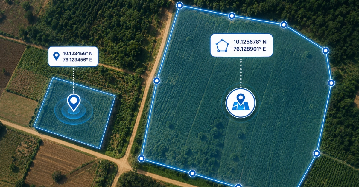
| ≤ 4 hectares, or cattle establishment | Single point (one lat / one long) | One central coordinate, 6+ decimals |
| > 4 hectares (non-cattle commodities) | Polygon (≥ 4 non-aligned points) | Full plot perimeter, no self-intersections |
Note: a central point with a circumference is not an accepted substitute for a polygon on plots over four hectares.
This is where buyers get caught out. Under EUDR geolocation requirements, the operator usually the EU-based importer or first placer on the market is fully responsible for the accuracy of the geolocation, even when a producer or smallholder supplied it.
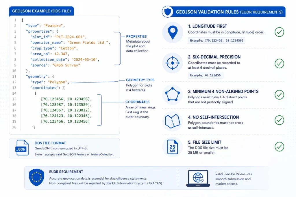
Once coordinates are captured, EUDR geolocation requirements dictate how they’re packaged for the TRACES system. The European Commission specifies GeoJSON for encoding the geographic data a “geometry” describing the shape, plus “properties” holding non-spatial attributes.
Coordinates can originate in different reference systems (UTM, WGS84, Lambert) and file formats (CSV, KML, Shapefile, GeoJSON), managed in tools like QGIS, ArcGIS, or Google Earth but they must arrive in TRACES as clean, valid GeoJSON.
Struggling with GeoJSON errors in your EUDR workflow?
Read our blog: “How to Validate GeoJSON Files for EUDR Compliance.”
Most rejections trace back to geolocation, not paperwork. If your supply chain runs through smallholders or aggregation points, the gaps are structural not careless.
A rejected DDS doesn’t just mean a fine. It means lost EU market access, broken brand trust, and a stalled supply chain.
Are GeoJSON errors slowing down your EUDR compliance process?
Read our blog: “Common GeoJSON Errors in EUDR Compliance and How to Fix Them.”
TraceX EUDR Solutions was built to close exactly these gaps turning fragmented field data into a TRACES-ready DDS without the manual scramble. Here’s how each capability maps to the requirement it solves.
Field agents capture accurate point and polygon coordinates, photograph land records, and register farmer profiles in zero-connectivity areas data syncs automatically when a signal returns. This is the only scalable way to meet EUDR geolocation requirements across India, Africa, and Southeast Asia.
Before any deforestation check runs, TraceX validates the integrity and structure of your GeoJSON through a 13-point geometry assessment confirming polygon boundaries are clean, closed, and EUDR-ready, so you catch the errors that cause DDS rejections upstream.
Once geometry is confirmed valid, TraceX runs a deforestation risk analysis against two trusted, EU-accepted satellite datasets, verifying plots against the 31 December 2020 cut-off.
TraceX captures farm-gate transaction data at the first point of purchase which farmer, what quantity, from which geolocation, on what date creating a digital aggregation ledger that preserves plot-level traceability even as physical commodities commingle.
With an API-ready integration to TRACES NT, verified supply-chain data goes from validated to submitted in minutes instead of the days-to-weeks manual DDS preparation takes, an up-to-80% reduction in compliance prep time.
“I’m a compliance lead at an EU cocoa importer sourcing from 3,000 smallholders in West Africa with no formal land titles. I need plot-level polygons, deforestation-free proof against the 2020 cut-off, and a valid DDS reference before cargo reaches Rotterdam.” — TraceX captures the plots offline through cooperatives, validates the GeoJSON, cross-checks satellite data, and files the DDS to TRACES NT.
Teams typically meet EUDR geolocation requirements one of three ways. Here’s how the approaches stack up on the capabilities that actually prevent DDS rejections.
| Capability for EUDR geolocation requirements | Spreadsheets / manual GIS | Single-point GPS tool | TraceX EUDR Platform |
|---|---|---|---|
| Offline plot capture (no signal) | No | Sometimes | Yes |
| Polygon + point in one workflow | Manual | Point only | Yes |
| GeoJSON geometry validation before submission | No | No | 13-point check |
| Satellite deforestation cross-check (post-2020) | No | No | Yes |
| Batch-to-plot linkage after aggregation | No | No | Yes |
| One-click DDS to TRACES NT | No | No | Yes |
| 5-year audit-ready record retention | Fragile | Partial | Yes |
Ready to submit your EUDR Due Diligence Statement (DDS)?
Read our blog: “How to File an EUDR Due Diligence Statement (DDS): A Step-by-Step Guide.”
Yes. Regardless of a country’s risk level, all operators must provide geolocation point or polygon for the origin of every commodity.
No. Plot-level geolocation must be collected and validated before the Due Diligence Statement is submitted.
Geolocation of the plot is still required, but the regulation doesn’t demand personal land-registry data only the coordinates of the plot supplying the commodity, provided the farmer can legally sell under local law.
Plots of 4 hectares or less (and cattle establishments) use a single point. Plots over 4 hectares require a polygon outlining the perimeter.
At least six decimal places, in decimal degrees, with longitude listed before latitude in GeoJSON.
Use offline-capable mobile capture tools that store GPS points and land records locally and sync once connectivity returns.


