Quick summary: Learn how bund agroforestry works, why polygon mapping is tricky, and how digital MRV unlocks scalable, audit-ready tree monitoring.
Bund agroforestry is the practice of planting trees along the raised earthen boundaries (bunds) that separate crop fields, rather than inside the fields themselves. It is one of the most widely adopted forms of agroforestry in smallholder geographies because it adds trees, income, soil protection and carbon value without sacrificing crop area. The hard part is not planting the trees it is measuring, monitoring and verifying them at scale.
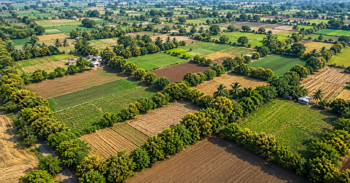
Walk through any smallholder landscape in India, sub-Saharan Africa, or Southeast Asia and you will see them single rows of neem, mango, casuarina or gliricidia threaded along the raised earthen ridges between paddy, millet, or vegetable fields. Farmers have been planting trees on bunds for generations. What is new is the pressure to count them.
Corporate net-zero commitments, voluntary carbon markets, and ESG-linked sourcing programs have turned every bund tree into a potential data point. The question is no longer whether bund agroforestry works decades of field evidence say it does. The question is how to onboard farmers, map narrow boundaries, geo-tag thousands of trees, track survival, and turn all of it into audit-ready reporting that a carbon registry or EU buyer will accept.
This guide walks through what bund agroforestry actually is, why smallholders prefer it, where projects break down, and what a credible digital monitoring stack looks like.
Three things to know: 1) Bund agroforestry plants trees on farm boundaries, delivering soil, water, biodiversity, income and carbon benefits without reducing crop area. 2) The biggest operational bottleneck is not agronomy it is polygon mapping, tree ownership, and survival tracking across thousands of narrow shared boundaries. 3) Digital MRV platforms (geo-tagging, farm polygon mapping, audit trails) are what make these projects fundable, verifiable and scalable for carbon and ESG programs.
Bunds are raised earthen ridges or embankments built along the edge or contour of a field. They are one of the oldest soil and water conservation structures in agriculture, especially common across the Indian subcontinent, the Sahel, and rice-growing regions of Southeast Asia.
This distinction matters for monitoring. Field bunds are linear a narrow strip a metre or two wide running between cultivated fields. Plantation blocks are dense, contiguous areas planted only with trees. A one-hectare plantation block might hold 1,100 trees in a tidy grid. The same hectare in bund agroforestry might hold 60–80 trees stretched along several hundred metres of boundary, often shared between two or three farmers. That linear geometry is what makes everything downstream mapping, ownership, carbon accounting harder.
Bund agroforestry is a boundary-planting agroforestry system where trees are integrated along the bunds of crop fields rather than inside them. The trees and the main crop share the same land parcel but occupy spatially distinct zones crops in the middle, trees on the edge. This is the defining feature that makes it attractive to smallholders.
In all three regions, bund agroforestry has emerged less as a deliberate scientific design and more as a generational adaptation farmers planting what feeds them, protects soil, and does not get in the way of the main crop. Today, the same systems are being formally enrolled in carbon and sustainability programs.
Discover how agroforestry supports sustainable agriculture and why it is gaining momentum across global supply chains and climate initiatives.
Read the full guide on Agroforestry for Sustainable Agriculture →
Bund agroforestry stacks six measurable benefits improved soil health, water conservation, additional income, biodiversity, carbon sequestration, and windbreak protection onto land that is already in agricultural use. Few other rural interventions deliver this combination without trade-offs.
Tree roots stabilise the bund itself and pump nutrients up from deeper soil layers. Leaf litter from species like gliricidia and leucaena adds nitrogen and organic matter to the topsoil, reducing fertiliser dependency over time.
Trees increase infiltration and reduce surface runoff. In semi-arid regions, mature bund trees can measurably raise local soil moisture and reduce the velocity at which monsoon rains wash sediment off the field.
Fruit (mango), fodder (gliricidia, leucaena), fuelwood (casuarina), timber (grevillea) and medicinal uses (neem) all open income streams that crops alone cannot. For smallholders managing one or two hectares, even 50–100 productive boundary trees can meaningfully diversify household income.
Boundary trees act as habitat corridors and re-introduce structural diversity into monoculture landscapes. Birds, pollinators and beneficial insects return to fields where bund trees provide nesting and refuge.
Above-ground biomass and tree-root systems lock away carbon dioxide. Bund trees may be fewer in number per hectare than a plantation block, but spread across millions of smallholder farms they represent one of the largest untapped reservoirs of nature-based climate mitigation in the Global South.
A row of mature trees breaks wind speed by 40–60% on the leeward side, reducing crop desiccation, protecting flowers from blow-off during pollination, and lowering moisture stress in dry-season crops.
Open bunds let water drain freely between fields; closed bunds hold water inside the field for irrigation. The choice between them is driven by rainfall, crop type, and soil and it changes how trees are planted, monitored, and counted.
Open bunds are low ridges with gaps or culverts that allow excess water to drain. They are common in upland crops, millet, vegetables, and any field where waterlogging would damage the crop. Trees on open bunds tolerate periodic drying neem, casuarina, and grevillea are typical.
Closed bunds are continuous, sealed ridges built to retain standing water the classic geometry of paddy rice fields and water-harvesting plots. Trees here must tolerate periodic waterlogging or be planted only on the outer face of the bund. Mango, gliricidia and leucaena are common where the bund is wide enough.
Globally, open bund systems dominate by area because rainfed agriculture covers more land than irrigated paddy. But in monsoon Asia, closed paddy bunds are where the densest and most numerous bund trees are found, particularly across Bihar, West Bengal, Bangladesh and the deltas of Vietnam and Myanmar.
| Attribute | Open Bunds | Closed Bunds |
|---|---|---|
| Water behaviour | Drains freely between fields | Retains standing water |
| Typical crops | Millet, vegetables, upland cereals | Paddy rice, water-harvesting plots |
| Common tree species | Neem, casuarina, grevillea | Mango, gliricidia, leucaena |
| Tree density per km of bund | Moderate (every 5–8 m) | High (every 3–5 m) |
| Mapping complexity | Lower — fewer overlaps | Higher — denser, narrower, more shared boundaries |
Explore how agroforestry contributes to carbon outcomes and discover the strategies organizations are using to design, monitor, and scale successful agroforestry programs.
Read the full guide on Agroforestry Solutions for Carbon →
Smallholders favour bund agroforestry because it costs almost nothing, takes almost no crop area, and pays back across multiple time horizons fodder this season, fuelwood next year, timber in a decade. It is the rare intervention that does not ask farmers to choose.
A two-hectare farm planted with trees on bunds loses perhaps 2–4% of its productive area. Compared with a block plantation that would consume the entire field, this is the difference between adoption and rejection.
Most bund species deliver more than one product. Gliricidia gives nitrogen-fixing fodder, fuelwood, and a quick-growing canopy. Mango gives fruit, shade and timber. This stacking is what smallholders price into the decision.
Seedling cost is low, no land has to be cleared, no irrigation needs to be redesigned. Many programs distribute saplings for free or at subsidised cost, making the on-ground cash outlay close to zero.
Bund agroforestry builds an asset that compounds. A neem planted today is income, shade, and inheritance for the next generation. This long-tail economics is exactly why bund agroforestry has survived in farmer practice for centuries before becoming a carbon project category.
Smallholders adopt bund agroforestry not because they have read the agronomy literature, but because the system matches the actual decision rules they use minimise downside, diversify income streams, plant what you can eat or sell, and never give up cropable land.
Neem, mango, gliricidia, grevillea, casuarina and leucaena are the six species that dominate bund plantings across South Asia and Africa. Each was selected by farmers not foresters for a specific combination of resilience, utility and growth rate.
| Species | Primary use | Best suited for | Carbon profile |
|---|---|---|---|
| Neem | Medicinal, biopesticide, shade | Semi-arid open bunds, India | Moderate, long-lived |
| Mango | Fruit, timber, shade | Sub-humid bunds, paddy edges | High biomass, long-lived |
| Gliricidia | Fodder, green manure, fuelwood | Closed bunds, mixed cropping | Fast carbon accrual, coppices well |
| Grevillea | Timber, fuelwood, shade | East African highlands | High, fast-growing |
| Casuarina | Fuelwood, windbreak, pulp | Coastal and sandy soils | Very high, nitrogen-fixing |
| Leucaena | Fodder, fuelwood, green manure | Drylands, mixed bund systems | Fast, nitrogen-fixing |
Species choice changes the entire MRV story. A grevillea-heavy project in Kenya will have different carbon accrual curves, survival risks and inventory cadence than a neem-heavy project in Rajasthan. Any monitoring system has to handle that diversity at the tree level, not the average.
The agronomy is the easy part. The hard part is governance, ownership, monitoring and replacement at scale, across thousands of farmers and tens of thousands of trees. These are the operational frictions where most bund agroforestry programs stall.
A bund is usually shared between two adjacent farmers. Who plants? Who waters? Who benefits when the tree produces? Programs that do not resolve this upfront watch trees die from neglect or get cut by the farmer who feels they have no claim.
Carbon programs need to attribute every tree to a specific farmer. On bunds, this is often unclear and the legal record (where one exists) rarely captures bund-line plantings. Without resolved ownership, no payment can be made and no carbon credit can be issued.
Seedling mortality in the first two years can run from 15% to 40% depending on rainfall, browsing pressure and species. Without a structured monitoring cadence, programs report planting numbers not surviving numbers and lose credibility with auditors and funders.
A real bund landscape mixes six or eight species across thousands of farms. Generic growth curves do not apply. Monitoring systems have to know which species is at which GPS point, with which farmer, planted in which year.
When a tree dies and is replanted, the project carbon math changes. Replacements have a new planting date, a new carbon curve and (often) a new species. Few paper-based systems track this; most carbon registries now require it.
Bund trees need protection from grazing, pruning to keep them from shading the crop, and periodic gap-filling. A program that pays for planting but not for ten years of stewardship leaves farmers without incentive to keep the trees alive.
What project teams are actually hired to do: • Prove the trees exist and survived (audit-ready evidence) • Attribute every tree to a farmer (for payment + ownership) • Capture species, year and growth at the tree level (for carbon math) • Report impact in a form a carbon registry or buyer will accept • Scale all of the above to 10,000+ farmers without breaking the field operations team
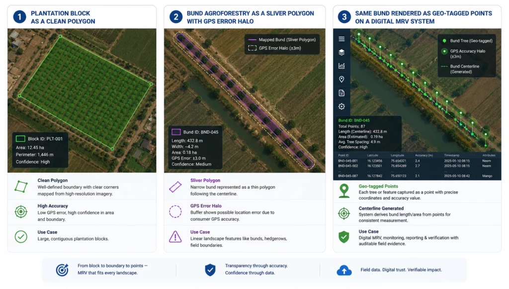
Polygon mapping in bund agroforestry projects is difficult because the trees are arranged in narrow linear strips along shared, irregular boundaries geometry that breaks the standard plot-polygon assumptions used in EUDR mapping, carbon registries and remote sensing tools. This is the single biggest reason bund agroforestry programs struggle to translate field reality into auditable data.
Discover why polygon mapping plays a critical role in carbon and compliance initiatives and learn the best practices for building trustworthy geospatial records.
Read the full guide on Polygon Mapping for Carbon and Compliance
Most polygon mapping tools assume an area a square paddock, a coffee plot, a polygon of palm. A bund is a line, often only a metre or two wide. Drawing a polygon around a single row of trees produces a sliver shape that some satellite layers and GIS tools cannot process reliably, and that carbon registries flag for review.
GPS error in low-end smartphones can range from 3 to 10 metres. On a 2-metre-wide bund, that error puts half your trees outside the polygon you drew. Without high-accuracy capture (RTK or post-processed kinematic) or careful field protocols, geo-data on bund trees is structurally noisy.
Because bunds are shared, a single line of trees can sit between Farmer A’s polygon and Farmer B’s polygon. If the trees are counted once for Farmer A and once for Farmer B, the project double-counts. If they are counted only once, one farmer loses payment. Resolving this requires explicit attribution logic, not just geometry.
Voluntary carbon registries Verra, Gold Standard, Plan Vivo increasingly demand tree-level geo-data with provenance. Linear bund geometry does not fit cleanly into hectare-based biomass models, forcing project developers to use point-based tree inventories layered onto farm polygons. That is technically achievable but operationally heavy without the right MRV platform.
The mismatch between linear bund geometry and area-based polygon tooling is the single most common reason agroforestry projects get downgraded or rejected during third-party audit even when the trees themselves are real and growing.
Credible tree monitoring in bund agroforestry rests on four data points captured per tree: a geo-tagged location, a photo, a survival status, and a periodic growth measurement. Without all four, the project cannot defend itself in audit.
Discover the key methods and technologies used to monitor trees in agroforestry systems and learn how digital tools can help scale impact across landscapes.
Read the full guide on Tree Monitoring in Agroforestry →
Every tree is captured as a GPS point with metadata species, planting date, farmer ID, plot ID. Modern field apps capture this in seconds and store it offline for later sync, which is essential in low-connectivity areas.
A timestamped, GPS-stamped photo at planting and at each subsequent visit creates an immutable evidence trail. Auditors increasingly require this as the minimum bar for proof of existence, especially for carbon credits.
A scheduled cadence typically 3, 12 and 24 months after planting captures whether each tree is still alive. Survival rate is the single most important number in any agroforestry project; without it, all downstream impact claims are speculative.
Diameter at breast height (DBH) and tree height feed directly into biomass equations and carbon calculations. Captured every 12–24 months, these measurements anchor the carbon claim in observation, not in averages from a literature table.
Bund trees sequester carbon in three pools above-ground biomass, below-ground roots, and soil organic carbon and across millions of smallholder farms they represent a material reservoir of low-cost nature-based mitigation. The maths is real; the proof is what is hard.
A mature neem on a bund can store roughly 200–300 kg of CO₂-equivalent over a 20-year horizon, depending on growth conditions. Multiply by 50–80 trees per hectare of bund-equivalent linear length, then by tens or hundreds of thousands of farmers in a program, and the total reaches industrially relevant scale.
Unlike plantation blocks, bund agroforestry does not compete with food production. This makes it one of the few climate interventions that delivers carbon sequestration, farmer income, and food security on the same hectare a stack that policymakers, donors, and carbon buyers increasingly prioritise.
Bund agroforestry is eligible under most major voluntary carbon standards, provided the project can produce tree-level evidence and demonstrate additionality (the trees would not have been planted without the project). The eligibility is well established. The operational MRV that is where projects either succeed or stall.
Designing a bund agroforestry project? See how TraceX’s Digital MRV platform handles farmer onboarding, polygon mapping and tree-level monitoring in one system.
Digital MRV (Measurement, Reporting and Verification) turns bund agroforestry from a well-meaning intervention into a fundable, auditable, scalable program. Without it, every program runs on field notebooks, hopeful estimates, and reports that fall apart under audit scrutiny.
Every farmer’s plot is captured as a digital record boundaries, ownership, planted area, crop history. This becomes the spine on which every tree-level event hangs.
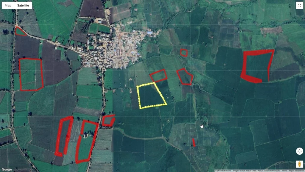
Farm polygons are drawn either by field officers walking the boundary with a GPS app or by validating remote-sensing-derived polygons against satellite imagery. Bund lines are captured as linear features layered onto the polygon, with each tree as a point feature on that line.
Each tree gets a unique ID, GPS location, species, planting date, and farmer attribution. This is the unit of record for every downstream metric survival, growth, carbon.
Every action planted, photographed, measured, replaced is recorded with timestamp, user, and (ideally) blockchain-backed immutability. When a third-party auditor arrives, the project does not scramble. The history is already there.
CSRD, TNFD, SBTi, Verra, Gold Standard every reporting framework now wants tree-level, traceable evidence. Digital MRV makes that reporting a query, not a months-long manual data assembly exercise.
Discover how dMRV is helping agroforestry projects scale impact, improve transparency, and support carbon and sustainability objectives.
Read the full guide on dMRV for Agroforestry Projects →
TraceX brings together farmer onboarding, polygon mapping, tree inventory, monitoring, and ESG/carbon reporting in a single Digital MRV platform purpose-built for emerging-market agroforestry. The platform was designed from the start for the operational reality of bund systems narrow boundaries, smallholder devices, intermittent connectivity, and audit-grade evidence requirements.
Multilingual, offline-first mobile apps let field officers register farmers, capture KYC, geotag plots, and record household profiles without needing connectivity. Once the device hits a network, everything syncs.
GPS polygon capture validated against satellite imagery. For bund systems, linear features are captured as line geometries layered on the parcel polygon, so trees on shared boundaries can be attributed unambiguously to the correct farmer.
Every tree is registered with a unique ID, species, planting date, GPS location, photo and farmer attribution. Replacements, mortality and growth measurements are captured against the same record preserving a continuous lifecycle history per tree.
Configurable monitoring cadences (3 / 12 / 24 months) drive structured field visits. Survival, growth and condition data feed dashboards in real time. Photo evidence with GPS and timestamp is immutable and exportable for third-party audit.
One-click export of audit-ready reports aligned to CSRD, SBTi, SBTN, TNFD and the major voluntary carbon registries. Blockchain-backed data integrity ensures the same numbers appear in the buyer report, the registry submission, and the internal dashboard.
Trees on bunds are easy to dismiss because there are few of them per hectare and they sit at the margins of the field. That is exactly why they are powerful. They cost nothing in crop area, they stack six measurable benefits, and they accumulate across millions of smallholders into a climate, livelihood and biodiversity dividend nothing else can match.
The pivot from agronomic possibility to verifiable program rests on one thing digital infrastructure. Farmer onboarding at scale. Polygon and linear feature mapping. Tree-level geo-tagging and lifecycle tracking. Audit-ready reports a buyer or registry will accept on first submission. That is the work TraceX exists to do.
Bund agroforestry is not new. What is new is the ability to count it, prove it, and pay for it at the scale climate goals now demand.
Bund agroforestry is the practice of planting trees along the raised earthen boundaries of crop fields. It is important because it delivers soil conservation, water retention, additional farmer income, biodiversity, carbon sequestration and windbreak protection all without reducing the cropped area, which makes it uniquely attractive in smallholder landscapes across India, Africa and Southeast Asia.
Polygon mapping is difficult because bund trees are arranged in narrow linear strips along shared, irregular field boundaries. Standard area-based polygon tools struggle with sliver geometries, GPS error often exceeds the bund width, and shared boundaries between farmers create attribution problems. Resolving this requires a Digital MRV platform that supports linear features and point-based tree inventories alongside farm polygons.
The most widely used species are neem (medicinal, shade), mango (fruit, timber), gliricidia (fodder, green manure), grevillea (timber, fuelwood), casuarina (windbreak, fuelwood) and leucaena (fodder, nitrogen fixation). Species choice depends on rainfall, soil, bund type (open vs closed) and the farmer’s priority fodder, fuel, fruit or carbon.
Yes. Bund agroforestry is eligible under most major voluntary carbon registries including Verra, Gold Standard and Plan Vivo, provided the project can demonstrate additionality and provide tree-level geo-tagged evidence with survival monitoring and growth data. Digital MRV is what makes that evidence layer practically possible at smallholder scale.
Digital MRV (Measurement, Reporting and Verification) replaces paper notebooks with a structured digital system that captures farmer profiles, farm polygons, tree-level geo-tags, photo evidence, survival data and growth measurements. It produces audit-ready reports aligned to CSRD, TNFD and carbon registry standards turning bund agroforestry from a well-intentioned activity into a fundable, scalable program.


