Quick summary: Learn how geo mapping for coffee exporters in Nigeria supports EUDR compliance with GPS polygon mapping, traceability, deforestation checks, and supply chain data validation.

Regulation (EU) 2023/1115 commonly called EUDR applies directly to coffee, one of Nigeria’s emerging agricultural export commodities. Entering into force on June 29, 2023, with compliance deadlines starting December 30, 2024, the regulation identifies coffee as one of seven commodities linked to deforestation risk, alongside cattle, cocoa, palm oil, rubber, soya, and wood. Geo mapping for coffee exporters in Nigeria is becoming a critical capability, enabling accurate data capture, validation, and compliance at scale. This guide walks through each element of that process.
Core Legal Obligations
Operators and traders placing coffee or coffee-derived products on the EU market must demonstrate three essential conditions before any shipment is accepted:
The Geolocation Mandate
Article 9 of EUDR makes geolocation mandatory for coffee supply chains. Because coffee is a land-based commodity, exporters must provide precise geographic data for every plot where coffee is grown.
Key data requirements include:
For Nigeria’s coffee sector still developing but increasingly integrated into global supply chains building scalable geo-mapping capabilities is essential. Accurate GPS polygon data collection, validation, and integration into traceability systems will form the foundation of EUDR compliance and ensure continued access to the EU market.
Nigeria Coffee Exports
Nigeria’s coffee export profile is relatively small and largely overshadowed by cocoa and other agricultural commodities, but it still has room to grow through quality improvement, processing, and niche specialty markets. The strongest story is not scale today, but the potential to build a more structured export base around Arabica from higher-altitude areas and better traceability in the value chain.
Data and Market Structure
Publicly available export data for Nigeria’s coffee sector is limited and often fragmented across green coffee, roasted coffee, and coffee preparations. What is clear is that Nigeria is not yet a major global coffee exporter, and its export volumes remain very small compared with leading African origins such as Ethiopia, Uganda, and Kenya.
The sector is concentrated in smallholder production, with limited commercial processing capacity and weak aggregation systems. That means export performance tends to be inconsistent, and much of the opportunity is still tied to domestic consumption, informal trade, and small specialty lots rather than large-scale export volumes.
Insights
Nigeria’s biggest coffee export opportunity is specialty positioning, not bulk volume. Buyers in premium markets are more likely to respond to traceable, origin-specific coffees with clear quality differentiation than to commodity-grade supply.
The main constraints are productivity, quality control, logistics, and limited investor confidence in the supply chain. Strengthening farmer organization, post-harvest handling, and traceability would do more to improve export earnings than simply expanding planted area.
Why It Matters
For exporters, Nigeria can become a niche origin with higher unit values if it can consistently deliver traceable, high-quality beans. For buyers, the market offers diversification potential, especially if climate change and supply risks push roasters to look beyond traditional origins.
A practical near-term strategy would be to focus on:
GeoJSON Errors Can Delay EU Shipments
Verify farm boundaries, fix formatting issues, and ensure your data is ready for DDS submission.
Why Geolocation (GPS Polygons) Is Mandatory for Nigeria’s Coffee Supply Chain
Under Regulation (EU) 2023/1115 (EUDR), GPS polygon mapping is not a procedural formality it is the technical foundation that enables verification of deforestation-free coffee. For exporters in Nigeria, where coffee is produced across smallholder farms often located near forest zones and mixed-crop systems, precise geolocation is essential to prove compliance and maintain EU market access.
The Satellite Verification Pipeline
EU authorities and third-party verifiers rely on satellite monitoring systems such as the Copernicus Programme, European Space Agency’s Sentinel missions, and Global Forest Watch to detect deforestation at the plot level. This verification process only works when exact farm boundaries are provided.
The verification logic for Nigeria’s coffee supply chain operates as follows:
Why Points Are Not Enough
Older traceability systems in Nigeria’s coffee sector sometimes relied on single GPS points (centroids) to represent farms. EUDR explicitly rejects this approach in favor of polygons for several critical reasons:
Regulatory Note
For coffee plots smaller than 4 hectares, EUDR technical guidance allows a minimum of four coordinate pairs forming a closed polygon. Larger plots must reflect the true and accurate shape of the farm boundaries.
Using simplified shapes such as square bounding boxes for irregular coffee farms is considered non-compliant, as it can misrepresent land use and lead to incorrect deforestation assessments.
Understand EUDR geolocation requirements in detail.
Learn how to capture accurate GPS polygons and ensure compliance.
Avoid common GeoJSON errors in EUDR submissions.
Learn how to validate and correct your geolocation data.
Challenges in Nigeria Coffee Sourcing
Nigeria’s coffee supply chain—still developing but increasingly integrated into global markets—faces structural and operational complexities that make EUDR compliance particularly demanding compared to more consolidated coffee systems in countries like Brazil.
Fragmented Smallholder Landscape
A significant share of coffee production in Nigeria comes from smallholder farmers, many cultivating plots under 1–3 hectares across regions such as Cross River, Taraba, Plateau, and parts of the Middle Belt. Key challenges include:
Geographic and Infrastructure Barriers
Nigeria’s coffee-growing regions present a mix of terrain and infrastructure challenges:
Supply Chain Traceability Gaps
Nigeria’s coffee supply chain is multi-layered and loosely structured:
This structure creates:
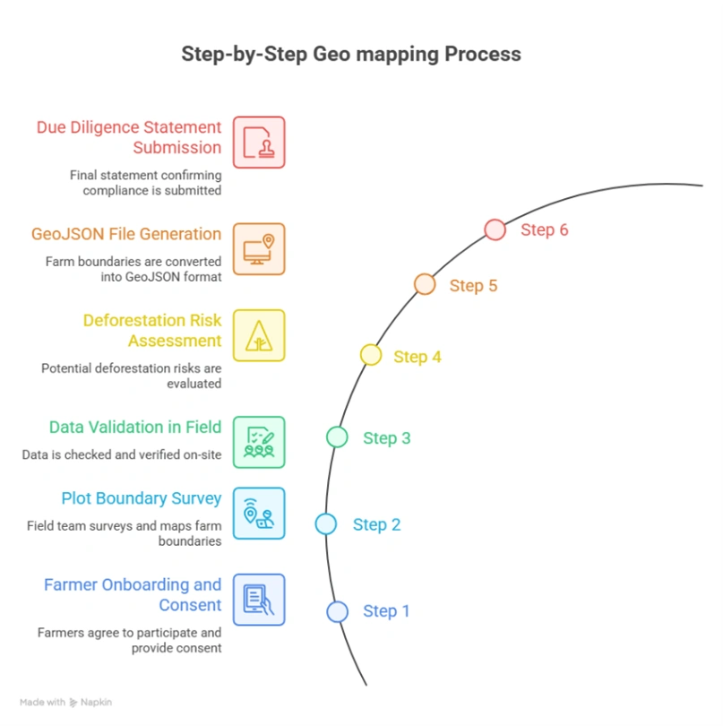
Step-by-Step Geo-Mapping Process for Nigeria Coffee
Below is a practical, field-tested workflow tailored to Nigeria’s coffee sector, designed to meet EUDR requirements while addressing on-ground realities.
Step 1: Farmer Onboarding and Consent
Before mapping begins, exporters must establish a compliant data-collection framework:
Step 2: Plot Boundary Survey
Field teams use GPS-enabled smartphones or GNSS devices to capture farm boundaries:
Step 3: Data Validation in the Field
Immediate validation ensures data quality before leaving the farm:
Step 4: Deforestation Risk Assessment
Captured polygons must be screened against deforestation datasets:
Step 5: GeoJSON File Generation
Validated polygon data must be standardized for submission:
| Geometry type | Polygon (Feature) |
| Coordinate system | WGS 84 (EPSG:4326) mandatory |
| Coordinate order | Longitude first, then Latitude (per GeoJSON spec) |
| Winding order | Exterior ring: counter-clockwise |
| Properties | farmer_id, plot_id, area_ha, crop_type, country, region |
| Encoding | UTF-8 |
| Validation tool | geojsonlint.com, QGIS geometry validator, or Turf.js |
Step 6: Due Diligence Statement Submission
The final compliance step links geolocation data to EU reporting systems:
Enabling Scalable Compliance
Geo-mapping for coffee exporters in Nigeria can be streamlined through digital platforms that integrate GPS polygon capture, automated validation, satellite verification, and compliance reporting helping exporters meet EUDR requirements while improving transparency and long-term supply chain resilience.
As Nigeria’s coffee sector scales, digital traceability systems will play a critical role in bridging data gaps, enabling aggregation across fragmented supply chains, and ensuring consistent compliance across thousands of smallholder farmers.
Geo mapping for coffee exporters in Nigeria becomes seamless with TraceX EUDR solutions, enabling accurate GPS polygon capture, real-time validation, and end-to-end compliance management ensuring exporters can confidently access EU markets with verified, deforestation-free supply chains.
Data quality failures at the polygon level are the single most common reason EUDR submissions are flagged for review or rejected. Field teams and data managers should be trained to identify and fix the following errors:
| Error Type | Description | Impact | Fix |
| Self-Intersection | Polygon boundary crosses itself, creating a ‘bowtie’ shape. Occurs when field agent reverses direction while walking. | Fails GeoJSON validation; geometry engine cannot compute area. | Re-walk boundary; use QGIS Fix Geometries tool. |
| Unclosed Ring | First and last coordinate pair do not match. Polygon ring is not closed. | GeoJSON spec violation; most validators reject outright. | Append first coordinate to end of ring, or use auto-close in KoboToolbox. |
| Wrong CRS | Coordinates recorded in VN-2000 (Vietnam national projection) or UTM instead of WGS 84. | Coordinates displaced by hundreds of meters from true location. | Reproject to EPSG:4326 using QGIS or GeoPandas. |
| Reversed Winding Order | Exterior ring wound clockwise instead of counter-clockwise per RFC 7946. | Some parsers treat interior of polygon as exterior; area inversion. | Reverse coordinate array; QGIS ‘Rewind Polygons’ tool. |
| Coordinate Swap | Latitude and longitude values transposed (lat first, instead of GeoJSON spec’s lon first). | Plot placed in wrong hemisphere or ocean; immediate deforestation false-alarm. | Validate first coordinate: Vietnam lon ≈ 102–109°E; lat ≈ 8–23°N. |
| Spike Artefacts | One or more vertices are outliers caused by GNSS signal bounce under canopy. | Polygon area inflated; boundary bleeds into adjacent plots. | Remove outlier points; apply Douglas-Peucker simplification at 1m tolerance. |
| Duplicate Polygons | Same farm submitted twice with different farmer_id due to aggregator duplication. | Inflated area records; compliance review flags double-counting. | Spatial deduplication using PostGIS ST_Equals or Turf.js booleanEqual. |
| Overly Simplified Polygon | Only 3 or 4 vertices used for complex, irregularly shaped plots. | True boundary not captured; adjacent deforested land may be excluded or included. | Minimum 6–8 vertices for plots with non-linear edges; re-survey if needed. |
For coffee exporters in Nigeria, EUDR compliance is not just a documentation requirement it represents a full-scale transformation of the supply chain. At the center of this shift is GPS polygon mapping, which creates a verifiable connection between each coffee plot, its land-use history, and the beans entering the European market.
The challenges are real: fragmented smallholder farms, limited formal land records, and the complexity of collecting accurate geospatial data across remote and underserved regions. Yet the path forward is clear. Exporters that invest early in scalable geo-mapping infrastructure combining mobile data collection, GIS-based validation, deforestation risk screening, and seamless integration with EU compliance systems will not only meet regulatory requirements but also gain a long-term competitive advantage.
The deadline is approaching. Geolocation is the foundation. Build it right.
Explore the tools you need for EUDR compliance.
Discover how coffee exporters are using digital solutions for geolocation, traceability, and DDS submission.
Understand EUDR compliance requirements for coffee supply chains.
Learn what exporters must do to ensure deforestation-free sourcing.
Learn how coffee exporters in Nigeria can meet EUDR requirements.
Explore geolocation, traceability, and compliance workflows tailored to Nigeria.
Geo mapping for coffee exporters in Nigeria involves capturing GPS polygon coordinates of coffee farms to verify origin, ensure traceability, and comply with EUDR deforestation-free requirements.
Geo mapping is mandatory under the EU Deforestation Regulation because it enables authorities to verify that coffee is not sourced from land deforested after December 31, 2020.
Exporters must collect:
Geolocation data is typically captured using:
Key challenges include:
Digital solutions help address these challenges through automated validation, satellite-based risk analysis, and end-to-end traceability systems.


