Quick summary: Regulation (EU) 2023/1115, commonly called the EU Deforestation Regulation, applies directly to cocoa, one of Indonesia’s important agricultural commodities within its diversified export economy. Entering into force on June 29, 2023, with compliance deadlines starting December 30, 2024, the regulation identifies cocoa as one of seven commodities linked to deforestation risk, alongside cattle, coffee, palm […]

Regulation (EU) 2023/1115, commonly called the EU Deforestation Regulation, applies directly to cocoa, one of Indonesia’s important agricultural commodities within its diversified export economy. Entering into force on June 29, 2023, with compliance deadlines starting December 30, 2024, the regulation identifies cocoa as one of seven commodities linked to deforestation risk, alongside cattle, coffee, palm oil, rubber, soya, and wood.
Geo mapping for cocoa exporters in Indonesia is becoming a critical capability, enabling accurate data capture, validation, and compliance at scale. This guide walks through each element of that process.
Operators and traders placing cocoa or cocoa-derived products on the EU market must demonstrate three essential conditions before any shipment is accepted:
Article 9 of EUDR makes geolocation mandatory for cocoa supply chains. Because cocoa is a land-based commodity, exporters must provide precise geographic data for every plot where cocoa is grown.
Key data requirements include:
For Indonesia’s cocoa sector characterized by smallholder farmers, decentralized production systems, and strong involvement of cooperatives and intermediaries building scalable geo-mapping capabilities is essential. Accurate GPS polygon data collection, validation, and integration into traceability systems will form the foundation of EUDR compliance and ensure continued access to the EU market.
| Coordinate type | GPS polygons (lat/long pairs forming a closed boundary) |
| Accuracy standard | Parcel-level, sufficient to verify against satellite forest-cover data |
| Cut-off date | December 31, 2020 (forest cover must be intact at this date) |
| Format requirement | GeoJSON or compatible geospatial format |
| Linked documentation | Due diligence statement referencing coordinates |
| Submission system | EU TRACES / dedicated EUDR IT platform |
Indonesia’s cocoa export story is shifting from a raw-bean model toward more processed and value-added exports, even as domestic bean supply remains constrained. In 2023, Indonesia exported US$1.2 billion of cocoa and cocoa preparations, while trade data for cocoa beans alone show US$46.9 million in exports and 14.45 million kg shipped in 2023.
Indonesia is still a major cocoa producer, but output has been under pressure for years, with one recent estimate putting 2023 cocoa bean production at around 650,612 tons after several years of decline from earlier highs. At the farm level, the sector is dominated by smallholders, and more than 1.5 million farmers are involved in cocoa, which makes quality consistency and traceability difficult but also creates room for productivity gains. The country imported US$304.41 million worth of cocoa and cocoa products in January 2025 alone to feed domestic processing and export activity, showing that Indonesia is increasingly reliant on imported raw cocoa to support its industrial base.
The strongest pattern is that Indonesia is becoming more important as a cocoa processing hub than as a pure bean exporter. Historical trade data show that processed cocoa exports expanded sharply after export taxes encouraged more domestic grinding and semi-processed exports, with cocoa butter, powder, paste, and chocolate becoming the main export categories. That structure still matters today because it gives Indonesia more value capture than raw bean exports, even though the country’s declining plantation productivity limits upstream supply.
| Indicator | Time Period | Value / Quantity |
| Cocoa Bean Production (Estimate) | 2023 | 650,612 Tons |
| Total Cocoa & Cocoa Preparations Exports | 2023 | US$1.20 Billion |
| Cocoa Bean Exports (Volume) | 2023 | 14.45 Million kg |
| Cocoa Bean Exports (Value) | 2023 | US$46.90 Million |
| Cocoa Imports (Total Value) | January 2025 | US$304.41 Million |
The sector’s next growth phase depends less on planting new area and more on rehabilitating farms, improving yields, and securing traceable supply. Global cocoa consumption is expected to keep rising, and ethical sourcing requirements are becoming more important, which gives Indonesian cocoa a chance to upgrade into premium, sustainable, and origin-specific markets. But if production keeps falling, Indonesia will likely remain a net importer of raw cocoa even while it exports more processed cocoa products.
Indonesia matters because it already has processing scale, export experience, and a huge smallholder base that could support a stronger quality-led cocoa economy. The opportunity is to move from commodity blending toward differentiated cocoa powder, butter, nibs, and craft chocolate with better traceability and stronger farmer incomes. The main risk is that weak farm profitability keeps pushing farmers into other crops, which would tighten supply further and reduce the country’s long-term export potential.
Verify farm boundaries, fix formatting issues, and ensure your data is ready for DDS submission.
Why Geolocation (GPS Polygons) Is Mandatory for Indonesia’s Cocoa Supply Chain
Under the EU Deforestation Regulation, GPS polygon mapping is not a procedural formality it is the technical foundation that enables verification of deforestation-free cocoa. For exporters in Indonesia, where cocoa is predominantly cultivated by smallholder farmers across dispersed islands and agroforestry systems, precise geolocation is essential to prove compliance and maintain access to EU markets.
EU authorities and third-party verifiers rely on satellite monitoring systems such as the Copernicus Programme, European Space Agency’s Sentinel missions, and Global Forest Watch to detect deforestation at the plot level. This verification process only works when exact farm boundaries are provided.
The verification logic for Indonesia’s cocoa supply chain operates as follows:
Older traceability systems in Indonesia’s cocoa sector may rely on single GPS points (centroids) to represent farms. EUDR explicitly requires polygons instead, for several critical reasons:
For cocoa plots smaller than 4 hectares, EUDR technical guidance allows a minimum of four coordinate pairs forming a closed polygon. Larger plots must reflect the true and accurate shape of farm boundaries.
Using simplified shapes such as square bounding boxes for irregular cocoa farms is considered non-compliant, as it can misrepresent land use and lead to incorrect deforestation assessments.
Understand EUDR geolocation requirements in detail.
Learn how to capture accurate GPS polygons and ensure compliance.
Avoid common GeoJSON errors in EUDR submissions.
Learn how to validate and correct your geolocation data.
Indonesia’s cocoa supply chain large, decentralized, and smallholder-driven—faces structural and operational complexities that make EUDR compliance particularly demanding.
A significant share of Indonesia’s cocoa production comes from smallholder farmers, many cultivating plots under 1–3 hectares across regions such as Sulawesi, Sumatra, and Papua. Key challenges include:
Indonesia’s cocoa supply chain typically follows:
Smallholder farmers → collectors → cooperatives → traders → exporters → international buyers
This structure creates:
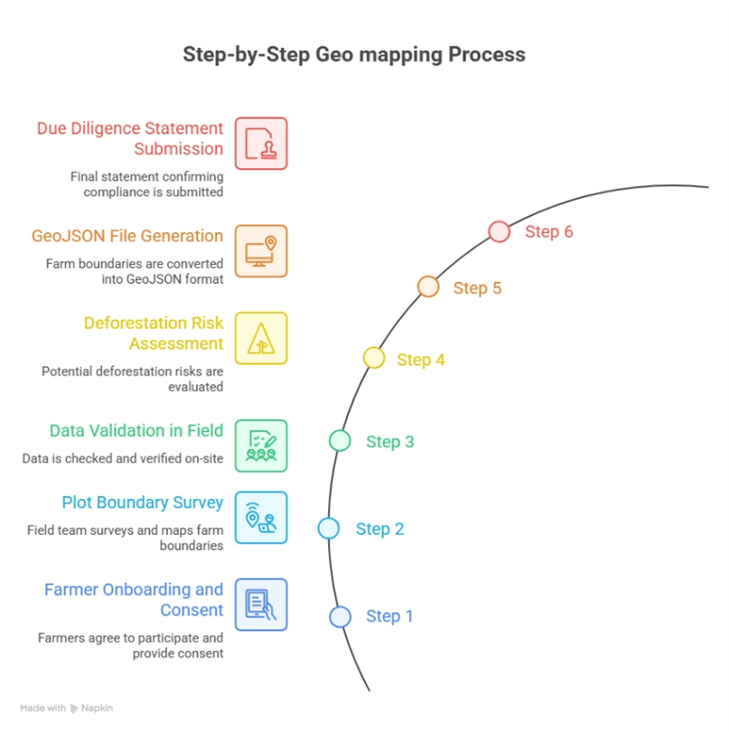
Step 1: Farmer Onboarding and Consent
Step 2: Plot Boundary Survey
Field teams capture boundaries using GPS-enabled smartphones or GNSS devices:
Step 3: Data Validation in the Field
Step 4: Deforestation Risk Assessment
Step 5: GeoJSON File Generation
| Geometry type | Polygon (Feature) |
| Coordinate system | WGS 84 (EPSG:4326) mandatory |
| Coordinate order | Longitude first, then Latitude (per GeoJSON spec) |
| Winding order | Exterior ring: counter-clockwise |
| Properties | farmer_id, plot_id, area_ha, crop_type, country, region |
| Encoding | UTF-8 |
| Validation tool | geojsonlint.com, QGIS geometry validator, or Turf.js |
Step 6: Due Diligence Statement Submission
The final compliance step links geolocation data to EU reporting systems:
Geo-mapping for cocoa exporters in Indonesia can be streamlined through digital platforms that integrate GPS polygon capture, automated validation, satellite verification, and compliance reporting helping exporters meet EUDR requirements while improving transparency and long-term supply chain resilience.
Geo mapping for cocoa exporters in Indonesia becomes significantly more efficient with EUDR solutions from TraceX, enabling accurate GPS polygon capture, real-time validation, and end-to-end compliance management across large-scale, geographically dispersed, and smallholder-driven cocoa supply chains.
Data quality failures at the polygon level are the single most common reason EUDR submissions are flagged for review or rejected. Field teams and data managers should be trained to identify and fix the following errors:
| Error Type | Description | Impact | Fix |
| Self-Intersection | Polygon boundary crosses itself, creating a ‘bowtie’ shape. Occurs when field agent reverses direction while walking. | Fails GeoJSON validation; geometry engine cannot compute area. | Re-walk boundary; use QGIS Fix Geometries tool. |
| Unclosed Ring | First and last coordinate pair do not match. Polygon ring is not closed. | GeoJSON spec violation; most validators reject outright. | Append first coordinate to end of ring, or use auto-close in KoboToolbox. |
| Wrong CRS | Coordinates recorded in VN-2000 (Vietnam national projection) or UTM instead of WGS 84. | Coordinates displaced by hundreds of meters from true location. | Reproject to EPSG:4326 using QGIS or GeoPandas. |
| Reversed Winding Order | Exterior ring wound clockwise instead of counter-clockwise per RFC 7946. | Some parsers treat interior of polygon as exterior; area inversion. | Reverse coordinate array; QGIS ‘Rewind Polygons’ tool. |
| Coordinate Swap | Latitude and longitude values transposed (lat first, instead of GeoJSON spec’s lon first). | Plot placed in wrong hemisphere or ocean; immediate deforestation false-alarm. | Validate first coordinate: Vietnam lon ≈ 102–109°E; lat ≈ 8–23°N. |
| Spike Artefacts | One or more vertices are outliers caused by GNSS signal bounce under canopy. | Polygon area inflated; boundary bleeds into adjacent plots. | Remove outlier points; apply Douglas-Peucker simplification at 1m tolerance. |
| Duplicate Polygons | Same farm submitted twice with different farmer_id due to aggregator duplication. | Inflated area records; compliance review flags double-counting. | Spatial deduplication using PostGIS ST_Equals or Turf.js booleanEqual. |
| Overly Simplified Polygon | Only 3 or 4 vertices used for complex, irregularly shaped plots. | True boundary not captured; adjacent deforested land may be excluded or included. | Minimum 6–8 vertices for plots with non-linear edges; re-survey if needed. |
For cocoa exporters in Indonesia, compliance with the EU Deforestation Regulation is not just a documentation requirement it represents a fundamental transformation of the supply chain. At the center of this shift is GPS polygon mapping, which creates a verifiable link between each cocoa plot, its land-use history, and the beans entering the European market.
The challenges are significant: highly fragmented smallholder systems, geographically dispersed farms across multiple islands such as Sulawesi and Sumatra, and the complexity of collecting accurate geospatial data in remote and forest-adjacent regions. Yet the path forward is clear. Exporters that invest early in scalable geo-mapping infrastructure combining mobile data collection, GIS-based validation, deforestation risk screening, and seamless integration with EU compliance systems will not only meet regulatory requirements but also gain a long-term competitive advantage.
The deadline is approaching. Geolocation is the foundation. Build it right.
Explore the tools you need for EUDR compliance.
Discover how cocoa exporters are using digital solutions for geolocation, traceability, and DDS submission.
Understand EUDR compliance requirements for cocoa supply chains.
Learn what exporters must do to ensure deforestation-free sourcing.
Learn how cocoa exporters in Indonesia can meet EUDR requirements.
Explore geolocation, traceability, and compliance workflows tailored to Indonesia.
FAQs
Geo mapping for cocoa exporters in Indonesia involves capturing GPS polygon coordinates of cocoa farms to verify origin, ensure traceability, and comply with EUDR deforestation-free requirements.
Geo mapping is mandatory under the EUDR because it enables authorities to verify that cocoa is not sourced from land deforested after December 31, 2020.
Exporters must collect:
Key challenges include:
Digital solutions help address these challenges through automated validation, satellite-based risk analysis, and end-to-end traceability systems.


