Quick summary: Learn how geo mapping for rubber exporters in Indonesia enables EUDR compliance through GPS polygon mapping, traceability, and accurate supply chain data validation.
The EU Deforestation Regulation (EUDR), effective December 30, 2024, requires that all rubber and rubber-derived products entering the EU market be provably deforestation-free.
At the core of this requirement lies precise geolocation: GPS polygon mapping of every plot of land where the commodity was produced.
Geo mapping for rubber exporters in Indonesia is rapidly becoming a mission-critical capability, especially given the country’s highly fragmented, smallholder-driven supply chains. It enables accurate data capture, validation, and compliance at scale ensuring continued access to EU markets.
This guide walks through each element of that process.
Regulation (EU) 2023/1115, commonly referred to as the EU Deforestation Regulation (EUDR), entered into force on June 29, 2023, with mandatory compliance deadlines beginning in late 2024.
It targets seven high-deforestation commodities: Rubber, Cattle, Cocoa, Coffee, Palm oil, Soya, and Wood.
As one of the world’s largest rubber producers, Indonesia is under increasing scrutiny to ensure that its exports meet strict traceability and deforestation-free requirements.
Operators and traders placing Indonesian rubber on the EU market must demonstrate three key conditions before export:
Article 9 of the EU Deforestation Regulation (EUDR) makes geolocation mandatory and non-negotiable.
For land-based commodities like rubber, exporters must provide precise geographic coordinates in the form of GPS polygons for every plot of land where the rubber was produced.
This requirement is particularly significant in Indonesia due to: large volumes of rubber sourced from smallholder farms, multi-layered supply chains with intermediaries, and limited historical availability of structured farm-level data.
| Requirement | Specification |
|---|---|
| Coordinate type | GPS polygons (lat/long pairs forming a closed boundary) |
| Accuracy standard | Parcel-level, sufficient to verify against satellite forest-cover data |
| Cut-off date | December 31, 2020 (forest cover must be intact at this date) |
| Format requirement | GeoJSON or compatible geospatial format |
| Linked documentation | Due diligence statement referencing coordinates |
| Submission system | EU TRACES / dedicated EUDR IT platform |
Indonesia remains one of the world’s largest rubber exporters. In the first seven months of 2025, Indonesia exported 968,000 tons of natural rubber, up 8% year on year, and total natural rubber plus mixed-rubber exports reached 999,000 tons, up 10% year on year.
Indonesia exported about US$3.14 billion of rubber in 2024, ranking second globally by export value. For 2023, technically specified natural rubber (TSNR) exports totaled US$3.05 billion with 1.79 billion kg volume.
| Indicator | Data |
|---|---|
| Rubber exports, 2024 (Value) | US$2.98 Billion |
| Natural rubber exports, Jan–Jul 2025 | 968,000 tons |
| Natural + mixed rubber exports, Jan–Jul 2025 | 999,000 tons |
| TSNR (SIR) exports, 2023 (Value) | US$3.05 Billion |
| TSNR export quantity, 2023 | 1.79 Billion kg |
Indonesia’s export mix is highly exposed to Asian demand, especially China. The country’s rubber sector is structurally shaped by smallholders, who account for around 80% of output, making traceability and productivity central to competitiveness. Around 75–80% of natural rubber production is exported, so global pricing and external demand have an outsized effect on farm incomes.
The main trend is that Indonesia is exporting more volume, but value growth is constrained by price pressure, product mix, and concentration in a few destination markets. Compliance and traceability are increasingly important as EU deforestation rules and buyer sustainability requirements reward verifiable sourcing.
Under the EU Deforestation Regulation (EUDR), GPS polygon data is the technical foundation of deforestation verification.
For Indonesia’s rubber sector where supply chains are fragmented across thousands of smallholder farms, precise geolocation is the only way to prove compliance at scale.
In Indonesia, where rubber farms are often irregular in shape, split across multiple small plots, and located near forest boundaries, using a single GPS point is insufficient and non-compliant.
Polygons are required because: a single point cannot represent complex or fragmented farm boundaries, it cannot distinguish between adjacent compliant and deforested land, satellite systems require area-based analysis not just location points, and polygon data enables accurate aggregation across thousands of smallholders.
Indonesia’s rubber supply chain presents significant structural, geographic, and traceability challenges. Over 80% of production comes from smallholder farmers with millions of plots spread across Sumatra, Kalimantan, and Sulawesi.
Major rubber-producing regions face logistical constraints: dense canopy interference (rubber trees 15–25 m height reduce GNSS signal accuracy), limited connectivity in many farm areas, seasonal accessibility issues during heavy rains, and frequent land-use conflicts between smallholder land, forest zones, and concession areas.
Indonesia’s rubber supply chain relies on informal networks making it difficult to link rubber batches to specific farm plots, validate deforestation-free claims, and maintain auditable records for EUDR compliance.
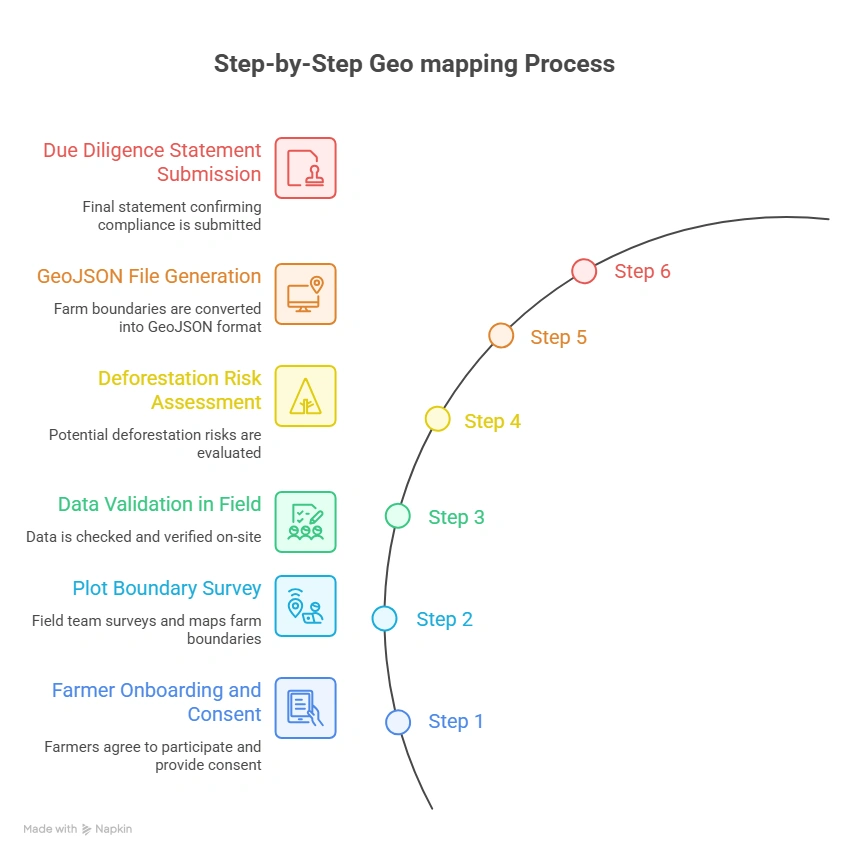
Below is a field-tested workflow designed for Indonesia’s rubber ecosystem, balancing compliance with on-ground realities.
| Specification | Value |
|---|---|
| Geometry type | Polygon (Feature) |
| Coordinate system | WGS 84 (EPSG:4326) mandatory |
| Coordinate order | Longitude first, then Latitude (per GeoJSON spec) |
| Winding order | Exterior ring: counter-clockwise |
| Properties | farmer_id, plot_id, area_ha, crop_type, country, region |
| Encoding | UTF-8 |
| Validation tool | geojsonlint.com, QGIS geometry validator, or Turf.js |
| Error Type | Description | Impact | Fix |
|---|---|---|---|
| Self-Intersection | Polygon boundary crosses itself, creating a ‘bowtie’ shape | Fails GeoJSON validation; geometry engine cannot compute area | Re-walk boundary; use QGIS Fix Geometries tool |
| Unclosed Ring | First and last coordinate pair do not match | GeoJSON spec violation; validators reject outright | Append first coordinate to end of ring or use auto-close |
| Wrong CRS | Coordinates recorded in wrong projection instead of WGS 84 | Coordinates displaced by hundreds of meters | Reproject to EPSG:4326 using QGIS or GeoPandas |
| Reversed Winding Order | Exterior ring wound clockwise instead of counter-clockwise | Some parsers treat interior as exterior; area inversion | Reverse coordinate array; use QGIS ‘Rewind Polygons’ tool |
| Coordinate Swap | Latitude and longitude transposed | Plot placed in wrong hemisphere; deforestation false-alarm | Validate first coordinate: Indonesia lon ≈ 95–141°E; lat ≈ 6°S–5°N |
| Spike Artefacts | Outlier vertices from GNSS signal bounce under canopy | Polygon area inflated; boundary bleeds into adjacent plots | Remove outliers; apply Douglas-Peucker simplification at 1m tolerance |
| Duplicate Polygons | Same farm submitted twice with different farmer_id | Inflated area records; compliance review flags double-counting | Spatial deduplication using PostGIS ST_Equals or Turf.js |
| Overly Simplified Polygon | Only 3–4 vertices used for complex, irregular plots | True boundary not captured; adjacent deforested land excluded/included | Minimum 6–8 vertices for non-linear edges; re-survey if needed |
For Indonesia’s rubber exporters, compliance with the EU Deforestation Regulation (EUDR) is not just a regulatory requirement it represents a fundamental transformation of the supply chain.
At the center of this transformation is GPS polygon-based geolocation, which creates a verifiable link between the farm plot, its deforestation history, and the rubber entering the EU market.
Indonesia’s challenges are substantial: smallholder dominance, fragmented landholdings, and inconsistent land documentation all make compliance more complex.
But the pathway forward is clear. Exporters that invest early in robust geo mapping systems combining mobile data collection, spatial data validation, deforestation risk screening, and digital compliance workflows will not only meet EUDR requirements but also gain a long-term competitive advantage in global markets.
The clock is running. Geolocation is the foundation. Build it right.
Explore the tools you need for EUDR compliance → Discover how Indonesian rubber exporters are using digital solutions for geolocation, traceability, and due diligence submission.
Understand EUDR compliance requirements for rubber supply chains → Learn what exporters must do to ensure deforestation-free sourcing.
Learn how rubber exporters in Indonesia can meet EUDR requirements → Explore geolocation, traceability, and compliance workflows tailored to Indonesia’s supply chain realities.
Geo mapping for rubber exporters in Indonesia involves capturing GPS polygon coordinates of rubber farms to verify origin and ensure compliance with deforestation-free requirements under the EU Deforestation Regulation (EUDR).
Geo mapping is mandatory under EUDR because it enables authorities to verify that rubber is not sourced from land deforested after December 31, 2020, using satellite-based analysis.
Exporters must collect: GPS polygon coordinates of farm plots, farmer identity and supplier details, land-use and ownership information (where available), crop and production data, and harvest and sourcing location details.
Geolocation data is typically captured using mobile mapping applications, GPS-enabled smartphones or GNSS devices, GeoJSON or KML file uploads, and field agents or cooperatives supported by digital traceability platforms.
Key challenges include highly fragmented smallholder farms, limited access to accurate land records, inconsistent or low-quality GPS data, complex aggregation networks, and difficulty validating deforestation risk. Digital solutions help address these through automated validation, risk analysis, and scalable traceability systems.


