Quick summary: Explore how satellite monitoring systems aid businesses in meeting EUDR compliance by tracking land-use and deforestation risks in real time. Learn how these tools ensure sustainability and regulatory adherence.
Imagine trying to verify that the wood or coffee your company sources has never contributed to deforestation—sounds like a huge task, right? This is exactly the challenge that the EU Deforestation Regulation aims to tackle. It’s a regulatory push from the European Union to ensure that key commodities like soy, palm oil, coffee, and wood entering the European market are deforestation-free. In simple terms, if your products have contributed to deforestation, they won’t make it to EU shelves. Satellite monitoring systems enable businesses to track land use from space in real time, offering a bird’s-eye view of sourcing areas.
According to Global Forest Watch, in 2022, the loss of tropical primary forests reached 4.1 million hectares, which translates to the destruction of 11 soccer fields of forest every minute. This deforestation resulted in emissions of 2.7 gigatonnes (Gt) of carbon
Businesses often don’t have full visibility over their supply chains. With manual tracking or fragmented data, staying compliant is like trying to hit a moving target. The fines for non-compliance can be hefty, not to mention the reputational damage. Satellite Monitoring systems allow for better risk assessment and provide the transparency needed to comply with EUDR requirements. Using satellite technology makes it easier to verify that products have been sourced sustainably, ensuring that supply chains remain deforestation-free. But how exactly does this technology work, and why is it becoming essential for modern supply chains?
Key Takeaways
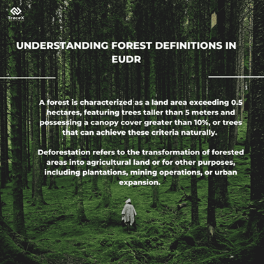
The European Union’s Deforestation Regulation requires businesses to verify that their products are not sourced from land cleared after December 31, 2020, highlighting the importance of accurate deforestation data for adherence. Deforestation frequently entails the transformation of wooded regions into farmland for agricultural production, which significantly contributes to rising global deforestation figures. Accurate deforestation data is vital to avoid supply chain interruptions, evade hefty fines, and ensure market access in the EU. While open-source deforestation data is accessible, it often falls short in precision and depth necessary for EUDR compliance, particularly in identifying critical land-use alterations. Proprietary deforestation analytics offer enhanced resolution, real-time tracking, and precise detection of land-use changes, minimizing the chances of false positives and negatives, thereby elevating overall compliance.
In recent years, ensuring compliance with environmental regulations, especially those related to deforestation, has become increasingly crucial for businesses. One of the most effective tools in this area is real-time satellite monitoring. This technology allows companies and regulators to keep an eye on forested areas continuously, helping them respond swiftly to any illegal deforestation activities.
Real-time deforestation monitoring involves using satellite technology to track changes in forest cover as they happen. Traditional monitoring methods often rely on ground surveys or periodic satellite images that can be days, weeks, or even months old. This delay can hinder quick action against illegal logging and other harmful practices.
With real-time monitoring, satellites equipped with advanced imaging technology can capture detailed images of forest areas continuously. This means that any deforestation activity can be detected almost immediately, allowing companies to take swift action to mitigate environmental impact and ensure EUDR compliance.
Different satellite technologies offer various benefits for monitoring deforestation:
By combining these technologies, companies can achieve comprehensive monitoring of forest areas, maximizing both clarity and coverage.
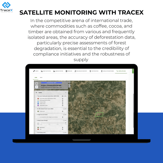
As the EU Deforestation Regulation (EUDR) comes into effect, companies are increasingly relying on technology solutions like satellite monitoring and blockchain traceability to ensure compliance. Satellite Monitoring platforms offer real-time insights into deforestation activities, enabling businesses to act swiftly and responsibly and satisfy the Risk assessment and mitigation requirements of EUDR.
Historical satellite data plays a crucial role in understanding deforestation patterns. By analyzing multi-year trends, businesses can identify areas at risk and predict future deforestation activities. This long-term view helps companies align their strategies with sustainability goals and compliance requirements, such as the EU Deforestation Regulation (EUDR).
Using historical data allows businesses to identify trends over time, making it easier to spot recurring deforestation hotspots. This is essential for proactive decision-making and long-term strategic planning. For example, areas with frequent illegal logging activities can be targeted for intervention or closer monitoring.
When companies conduct multi-year analysis, they can forecast potential environmental risks and adjust their sourcing strategies accordingly. This helps them stay ahead of deforestation regulations and manage supply chain risks better. Understanding the past makes future planning more informed and reliable.
Satellite Monitoring system provides detailed historical analysis of deforestation, helping companies assess environmental impacts over time. This insight is critical for understanding patterns and ensuring adherence to EUDR standards.
Historical satellite imagery is an essential element of EUDR compliance software. It enables businesses to demonstrate that deforestation has not occurred since the cut-off date of December 31, 2020.
This access to data allows companies to trace land use history and showcase the sustainability of their raw material sources. Firms involved in commodities such as palm oil, coffee, and soy—which are associated with deforestation—utilize this data to ensure responsible sourcing of their materials. By employing monitoring tools for deforestation, these companies can validate their adherence to EUDR regulations and reduce risks linked to unlawful land
Near-real-time deforestation alerts use satellite technology to detect changes in forest cover almost immediately. These alerts notify businesses and organizations about deforestation activities as they happen, allowing them to take swift action to prevent further damage. By providing instant insights, companies can better manage their supply chains and ensure compliance with environmental regulations, such as the EU Deforestation Regulation (EUDR). This proactive approach helps reduce illegal deforestation and promotes sustainable sourcing practices.
With near-real-time notifications, businesses can stay ahead of environmental changes. satellite monitoring system detects disturbances quickly, allowing for timely interventions that can mitigate risks associated with deforestation.
Monitoring deforestation in near-real time poses a major challenge for businesses. Satellite imagery plays a crucial role in addressing this issue, supplying high-resolution pictures that facilitate ongoing forest observation. Companies can utilize satellite monitoring systems , which provide alerts for deforestation and real-time tracking of changes in forest cover.
These resources are essential for quickly identifying illegal logging and unauthorized land clearing
Enhanced forest risk analysis and modeling use satellite imagery and data analytics to assess forest health, detect deforestation patterns, and predict potential risks. These models allow businesses to map areas of high deforestation risk, helping them make informed decisions about sourcing and compliance with regulations like the EU Deforestation Regulation (EUDR). By incorporating historical and real-time data, companies can better manage environmental risks and implement proactive strategies to protect forests while maintaining transparency in their supply chains.
Using advanced satellite imagery, these satellite monitoring systems can accurately identifies different crop types within supply chains, enhancing traceability and transparency. This capability not only supports compliance but also promotes sustainable farming practices.
Streamlined supplier data collection with satellite monitoring enables businesses to gather real-time, accurate information on sourcing regions. By integrating satellite data, companies can verify whether suppliers are compliant with sustainability and deforestation regulations, such as the EU Deforestation Regulation (EUDR). Automated tools, like APIs and secure links, simplify the process by allowing suppliers to provide relevant data with minimal effort. This transparency enhances supply chain management, helping businesses monitor environmental risks and ensure that their sourcing practices are deforestation-free and fully traceable.
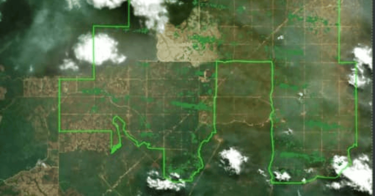
Platforms which specialize in satellite data monitoring, offer comprehensive risk mapping tools. These platforms provide businesses with clear, visual representations of deforestation risks, often integrating satellite imagery with other environmental data. This detailed mapping supports due diligence by showing real-time and historical data, helping organizations assess compliance with the EUDR.
Transparency is a fundamental aspect of EUDR. Companies must supply geolocation information for all the land where their commodities are obtained. Compliance platforms that incorporate satellite data allow businesses to provide verifiable evidence of the origin of their materials, improving supply chain transparency.
With detailed deforestation insights at hand, businesses can implement proactive compliance strategies. This might involve adjusting supplier relationships, sourcing from regions with low deforestation risks, or collaborating with stakeholders to reduce the impact on forests. By using historical and real-time satellite data, companies can avoid regulatory penalties and contribute to sustainable land management.
Businesses can significantly enhance supply chain visibility by integrating satellite monitoring data into existing management tools.
APIs (Application Programming Interfaces) allow seamless data flow from satellite monitoring systems into supply chain management platforms. These integrations enable businesses to automate processes like deforestation detection and environmental risk assessment. Automated alerts can be triggered when risks arise, helping companies quickly take action.
Automated alerts keep businesses informed in real-time. When satellite data detects illegal logging or deforestation, the system instantly notifies supply chain managers. This quick notification allows businesses to make informed decisions rapidly, preventing potential violations and maintaining compliance. Integration also reduces manual intervention, saving time and resources.
Industries like agriculture, forestry, and mining are increasingly using satellite monitoring to ensure sustainable practices. For example, agricultural companies use satellite alerts to monitor forest encroachment and adjust their sourcing strategies accordingly. Forestry companies, on the other hand, utilize these alerts to track logging activities and ensure they are compliant with deforestation regulations like the EUDR.
Ensuring that your supply chain is deforestation-free requires a combination of verification steps, audits, and certifications.
1. Steps for Verifying Deforestation-Free Sourcing
2. Third-Party Audits and Certifications
3. False deforestation alerts
The TraceX EUDR compliance platform offers a seamless solution for navigating the EU Deforestation Regulation (EUDR) by combining blockchain traceability, satellite monitoring, documentation workflows, and integration with ERP systems and the EU Due Diligence System (EU-DDS).
1. Blockchain Traceability enables end-to-end visibility across the supply chain, ensuring that commodities like soy, coffee, and palm oil are sourced from deforestation-free areas. Every transaction is securely recorded and verifiable, providing robust proof of compliance.
2. Satellite Monitoring offers real-time land-use data, helping businesses assess deforestation risks in supplier regions. This proactive monitoring ensures that companies stay ahead of potential EUDR violations.
3. Automated Documentation Workflows simplify compliance reporting by generating, storing, and managing necessary documentation, making it easy to provide authorities with verifiable evidence of deforestation-free sourcing.
4. Integration with Existing ERP Systems allows for smooth data flow between TraceX and companies’ internal systems, eliminating the need for manual data entry and ensuring efficient, real-time tracking across supply chains.
5. EU-DDS Integration ensures seamless compliance with the EU’s due diligence requirements, streamlining submission processes and aligning your data with regulatory expectations.
Together, these features provide companies with an all-in-one solution to navigate EUDR compliance with ease, reducing the burden of manual processes and ensuring traceability from source to shelf.
Satellite monitoring systems offer businesses an indispensable tool for achieving EUDR compliance. By providing real-time, precise insights into land-use and deforestation risks, they enable proactive action and accurate reporting, helping businesses meet stringent EU regulations. When combined with blockchain traceability, satellite monitoring becomes part of a comprehensive solution, ensuring companies maintain sustainable, deforestation-free supply chains while safeguarding their market access in the EU.
Satellite monitoring provides real-time data on land-use changes and deforestation risks, enabling businesses to proactively manage their supply chains and ensure they are sourcing from deforestation-free regions.
Yes, satellite monitoring can be integrated with blockchain traceability and other due diligence platforms, offering a holistic solution for EUDR compliance by connecting land-use insights with supply chain data.
Satellite monitoring offers real-time, accurate, and large-scale coverage, reducing the reliance on manual inspections and audits while enhancing the ability to detect and mitigate deforestation risks quickly.


