How Is EUDR Plot Data Verified? What Businesses Need to Know
Published
, 9 minute read
Share this article
Quick summary: EUDR plot data verification helps validate plot boundaries, detect missing or duplicate plots, reconcile volumes, and build audit-ready EUDR compliance.
EUDR plot data verification is the process of checking whether the geolocation and related source information provided for commodity-producing plots is accurate, complete, reliable, and consistent with the wider supply chain. Under EUDR, businesses must provide the geolocation of all relevant plots and the applicable production date or time range, then verify and analyse the collected information as part of their risk assessment. EUDR compliance does not end when a business collects geolocation coordinates and submits a Due Diligence Statement (DDS). The information behind the declaration can be examined by competent authorities, and businesses need to demonstrate that their plot data is complete, reliable and connected to the relevant products. Article 9 requires operators to collect the geolocation of all plots where relevant commodities were produced, together with the applicable production date or time range, and to make the information and supporting documentation available on request. Competent authorities use a risk-based approach that can consider supply-chain complexity, mixing, processing stage, country risk, adjacency to forests, previous non-compliance and risks of circumvention.
EUDR Plot Data Verification: Key Takeaways
EUDR requires geolocation of all relevant production plots and the applicable production date or time range.
Competent authorities use a risk-based approach and can consider circumvention, mixing, supply-chain complexity and other risk factors.
A declared polygon should be supported by a broader traceability record linking source, quantity and product.
Businesses should test whether declared plots plausibly account for relevant commodity volumes, avoid selective omission of genuine source plots, and validate boundaries using appropriate evidence and technical methods where relevant.
December 2026 is approaching. Is your supply chain actually ready?
Move from spreadsheets and fragmented supplier data to a traceable, audit-ready EUDR workflow with TraceX.
EUDR plot data verification is the process of checking whether the geolocation and related production information supplied for relevant commodities is credible, complete and consistent with the due diligence record. A supplier-submitted polygon is an important input, but it is not necessarily the end of verification. The wider question is whether the declared source information reasonably represents the commodity entering the supply chain. Businesses should therefore build verification controls before submission rather than waiting for an authority to identify inconsistencies.
Learn what geolocation data you need to collect, how plot boundaries and GeoJSON requirements work, and how to prepare your source-level data for EUDR compliance.
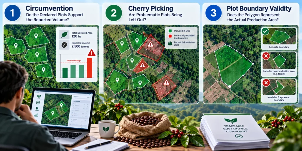
Check 1: Circumvention — Do the Declared Plots Support the Reported Volume?
One important risk is circumvention: whether the declared supply base is complete enough to plausibly account for the quantity of commodity entering the supply chain. The question is not simply whether a company has submitted some plots. It is whether the declared source information and production quantities make sense together. If reported procurement volumes appear inconsistent with the declared production areas, this can create a data-quality or circumvention concern. The EUDR requires operators to verify and analyse Article 9 information and conduct a risk assessment, while competent authorities can use risk criteria that include circumvention and supply-chain complexity.
Example: Coffee Supply Chain
An exporter reports 1,000 tonnes of coffee from 200 plots covering 400 hectares.
If the declared plots appear capable of producing only 500–600 tonnes, the discrepancy becomes a verification trigger.
It doesn’t automatically mean non-compliance. The operator should investigate whether additional plots, suppliers, yield variations, or processing conversion factors explain the difference.
Key check: Plot Area → Expected Yield → Reported Volume → Procurement Records
If the numbers don’t align, the data should be investigated before relying on it for EUDR due diligence.
A timber value-chain prospect raised an important EUDR concern: suppliers may repeatedly reuse the same source plot geolocation across multiple shipments. How can businesses verify that these plots genuinely support the cumulative timber volumes supplied, rather than the same plots being reused as compliance evidence?
What Should Businesses Compare?
A strong internal verification process can compare declared plot area and geometry, commodity type and production period, reported procurement quantity, reasonable production or yield assumptions, supplier-level procurement records, batch and inventory records, and potential mixing or unknown-origin material. The objective is not to claim that EUDR prescribes a single yield threshold. Rather, it is to identify material inconsistencies before they become an authority question.
Check 2: Cherry Picking — Are Problematic Plots Being Left Out?
A second concern is selective disclosure: declaring only plots that appear compliant while excluding other plots that may also be genuine sources of the commodity. Article 9 requires the geolocation of all plots where the relevant commodities used in the relevant product were produced. Businesses should therefore not treat plot selection as an exercise in choosing the most convenient locations. If multiple plots genuinely contributed to the relevant commodity, the traceability record needs to account for those sources.
For example, a coffee exporter sources coffee from 50 genuine production plots, but only declares geolocation for 35 plots because those plots have cleaner compliance records, while coffee from the remaining 15 plots is also mixed into the same shipment. If those 15 plots genuinely contributed to the relevant product, excluding them creates a gap in the traceability record. Article 9 requires the geolocation of all plots where the relevant commodity was produced, so the focus should be on accounting for the complete source base rather than selecting only the most convenient plots.
Why the Wider Supply Shed Matters
Authorities can apply risk-based checks and use information beyond the individual declaration. The Regulation allows competent authorities to use monitoring data, risk profiles, substantiated concerns and other relevant sources. The enforcement rules also allow technical and scientific means, including Earth observation data, to determine whether relevant products are deforestation-free. A robust process should reconcile declared plots against procurement and production records and ask whether every relevant source contributing to the product is represented.
Learn how to structure an effective EUDR risk assessment process and identify potential compliance gaps before they reach your EU shipments.
Check 3: Plot Boundary Validity — Does the Polygon Represent the Actual Production Area?
The third check concerns the validity of plot boundaries. A polygon can be technically valid as a GeoJSON file and still require substantive verification. Businesses need confidence that the boundary represents the land area associated with production rather than a boundary that has been altered to avoid relevant forest or deforestation information. Competent authorities may use Earth observation and other technical or scientific means when appropriate, making the quality of the underlying geometry important.
Example: Timber Plot Boundary Verification
Imagine a timber supplier submits a GeoJSON polygon for a 20-hectare plantation. The file is technically valid and uploads successfully, but when the operator compares the polygon with satellite imagery, the boundary appears to include only the cultivated portion while leaving out a forested area that may actually be part of the same production property.
That does not automatically mean the supplier has manipulated the data. However, it should trigger further verification: Does the polygon represent the actual production area? Does it match the farmer or land records? Where exactly was the timber harvested? Are the declared boundaries consistent with the source documentation?
This matters because competent authorities can use geolocation information and satellite/other monitoring tools as part of EUDR checks.
The key point: a GeoJSON can be technically valid but still require substantive verification.
What Plot Validation Should Include
A practical validation workflow can include coordinate and GeoJSON format validation; polygon geometry checks; area calculation; overlap and duplicate-plot detection; comparison with cadastral or other authoritative reference information where available; remote-sensing review; and checks for unexplained boundary changes. Where automated or satellite-derived boundaries are used, businesses should retain the methodology and evidence supporting how the production area was identified.
Learn how to identify common GeoJSON errors, validate plot geometry, and prepare reliable geolocation data for EUDR compliance.
TraceX EUDR Solutions can address these three risks through a connected EUDR plot verification and traceability workflow. It can compare declared plot areas and geolocation with procurement volumes and production data to flag unusual plot-to-volume relationships that require further verification; maintain visibility of all contributing plots and link them to suppliers, procurement records, batches and shipments, helping identify gaps where source plots may be missing; and validate GeoJSON geometry while overlaying plot boundaries with satellite and land-use data to identify potential inconsistencies between the declared polygon and the actual production area. Together, these capabilities create a traceable chain from Source Plot → Supplier → Production → Procurement → Batch → Risk Assessment → Evidence → EU Shipment, helping businesses identify anomalies before relying on the data for EUDR due diligence.
Submitting plot coordinates is only the beginning. TraceX helps businesses connect supplier data, geolocation, plot validation, satellite-based deforestation checks, procurement, traceability, risk assessment and compliance evidence in one connected workflow.
The EUDR enforcement framework allows competent authorities to examine the operator’s due diligence system, risk assessment and risk mitigation procedures, supporting documentation and records. Where questions arise, checks can extend to on-the-ground examinations, technical and scientific analysis, Earth observation data and field audits. Geolocation is therefore part of a broader evidence chain: a business should be able to connect a declared plot to the commodity produced there, relevant quantities, procurement transactions, production or batch records and the final product or shipment.
How to Build an EUDR Plot Data Verification Workflow
1. Collect — capture plot geolocation, production period, commodity, supplier and supporting evidence.
3. Reconcile — connect plots to supplier quantities, procurement, inventory, batches and shipments.
4. Assess — evaluate country risk, forest-related indicators, supply-chain complexity, mixing, circumvention and other Article 10 factors.
5. Verify — use appropriate satellite, cadastral, scientific or third-party evidence to investigate anomalies.
6. Document — record decisions, exceptions, corrective actions and supporting evidence so the assessment is reproducible.
Why Digital EUDR Plot Verification Matters
Spreadsheets can store coordinates, but complex supply chains require more than a list of polygons. Businesses need to connect geolocation with suppliers, procurement, quantities, batches, evidence and shipments while maintaining an audit trail of validation and risk decisions. A digital EUDR workflow can help identify missing plots, quantity inconsistencies, duplicate geometries, invalid boundaries and unresolved evidence gaps before a DDS is submitted.
Frequently Asked Questions (FAQ’s)
What is EUDR plot data verification?
It is the process of checking whether plot geolocation and related source information are complete, reliable, consistent and supported by evidence for EUDR due diligence.
Does EUDR require all plots to be declared?
Article 9 requires the geolocation of all plots where the relevant commodities used in the relevant product were produced.
Can competent authorities verify plots using satellite data?
Yes. The enforcement rules allow appropriate technical and scientific means, including Earth observation data, to help determine whether relevant products are deforestation-free.
Can authorities check the wider supply chain?
Yes. Risk-based criteria include supply-chain complexity, mixing and circumvention, and authorities can examine the due diligence system and supporting records.
Does a technically valid GeoJSON prove compliance?
No. File-format validity is only one part of verification. Reliable source information, traceability, risk assessment and supporting evidence are still needed.
Start using TraceX
Transparency, Trust, & Success for your Climate Journey.
We use cookies on our website to give you the most relevant experience by remembering your preferences and repeat visits. By clicking “Accept All”, you consent to the use of ALL the cookies. However, you may visit "Cookie Settings" to provide a controlled consent.
This website uses cookies to improve your experience while you navigate through the website. Out of these, the cookies that are categorized as necessary are stored on your browser as they are essential for the working of basic functionalities of the website. We also use third-party cookies that help us analyze and understand how you use this website. These cookies will be stored in your browser only with your consent. You also have the option to opt-out of these cookies. But opting out of some of these cookies may affect your browsing experience.
Necessary cookies are absolutely essential for the website to function properly. These cookies ensure basic functionalities and security features of the website, anonymously.
Cookie
Duration
Description
cookielawinfo-checkbox-analytics
11 months
This cookie is set by GDPR Cookie Consent plugin. The cookie is used to store the user consent for the cookies in the category "Analytics".
cookielawinfo-checkbox-functional
11 months
The cookie is set by GDPR cookie consent to record the user consent for the cookies in the category "Functional".
cookielawinfo-checkbox-necessary
11 months
This cookie is set by GDPR Cookie Consent plugin. The cookies is used to store the user consent for the cookies in the category "Necessary".
cookielawinfo-checkbox-others
11 months
This cookie is set by GDPR Cookie Consent plugin. The cookie is used to store the user consent for the cookies in the category "Other.
cookielawinfo-checkbox-performance
11 months
This cookie is set by GDPR Cookie Consent plugin. The cookie is used to store the user consent for the cookies in the category "Performance".
viewed_cookie_policy
11 months
The cookie is set by the GDPR Cookie Consent plugin and is used to store whether or not user has consented to the use of cookies. It does not store any personal data.
Functional cookies help to perform certain functionalities like sharing the content of the website on social media platforms, collect feedbacks, and other third-party features.
Performance cookies are used to understand and analyze the key performance indexes of the website which helps in delivering a better user experience for the visitors.
Analytical cookies are used to understand how visitors interact with the website. These cookies help provide information on metrics the number of visitors, bounce rate, traffic source, etc.
Advertisement cookies are used to provide visitors with relevant ads and marketing campaigns. These cookies track visitors across websites and collect information to provide customized ads.
Download the 2026 Traceability Scorecard and Benchmark Your Supply Chain Across 10 Critical Capabilities.
Download our eBook
Don’t Wait for an Audit to Find Your EUDR Gaps
The 2026 Simplification Package changes how HS codes, DDS pass-through and geolocation rules apply to you. Get the free guide and 20-point readiness checklist before enforcement catches you unprepared.