Quick summary: Learn how geo mapping for palm oil exporters in Indonesia supports EUDR compliance with GPS polygon mapping, GeoJSON validation, supplier traceability, and deforestation risk assessment.
Indonesia is one of the world’s largest producers and exporters of palm oil to the European Union, making compliance with the EU Deforestation Regulation increasingly critical for palm oil producers, refiners, processors, exporters, oleochemical manufacturers, FMCG suppliers, and downstream manufacturers. At the center of EUDR compliance lies precise geolocation: GPS polygon mapping of the plantations and sourcing areas where palm fruit was cultivated and harvested. Geo mapping for palm oil exporters in Indonesia is becoming a foundational capability for validating sourcing origin, demonstrating legality, and maintaining uninterrupted access to EU markets. This guide walks through the key requirements and operational considerations for achieving compliance at scale.
EUDR Deadlines Are Near
Start Your Free Trial Before Your Palm Oil Exports Face Compliance Risks
What the EU Deforestation Regulation Requires for Indonesia Palm Oil Exporters
Regulation (EU) 2023/1115, commonly referred to as EUDR, entered into force on June 29, 2023, with mandatory compliance obligations beginning in late 2024. The regulation targets seven high-risk commodities linked to deforestation and forest degradation, including palm oil and palm-derived products.
For Indonesia’s palm oil sector, EUDR introduces a major shift in how sourcing, legality, traceability, plantation monitoring, and supplier transparency must be managed across supply chains.
Core Legal Obligations
Operators and traders placing palm oil or palm-derived products on the EU market must demonstrate three core requirements before products can enter the EU:
• No deforestation: Palm oil must not originate from land deforested after December 31, 2020. • Legal compliance: Palm oil must be produced in accordance with Indonesian laws, including land-use rights, plantation permits, environmental regulations, labor obligations, cultivation approvals, and processing licenses. • Due diligence: Companies must conduct and document due diligence through a Due Diligence Statement (DDS) submitted to the EU Information System.
The Geolocation Mandate
Article 9 of EUDR makes geolocation mandatory for palm oil supply chains. Operators must provide precise geographic coordinates of the plantation plots where palm fruit was cultivated, typically through GPS polygon mapping.
Coordinate type
GPS polygons (lat/long pairs forming a closed boundary)
Accuracy standard
Parcel-level, sufficient to verify against satellite forest-cover data
Cut-off date
December 31, 2020 (forest cover must be intact at this date)
Format requirement
GeoJSON or compatible geospatial format
Linked documentation
Due diligence statement referencing coordinates
Submission system
EU TRACES / dedicated EUDR IT platform
For Indonesia palm oil exporters, this means: • Mapping plantation boundaries, smallholder farms, estates, and sourcing areas accurately • Collecting polygon-level geolocation data • Validating GeoJSON files before DDS submission • Linking fresh fruit bunch (FFB) sourcing records to export batches • Maintaining auditable traceability documentation across supply chains
Key Data Requirements Include:
• GPS polygon coordinates of plantation plots and sourcing areas • Supplier, plantation owner, and mill information • Palm fruit harvesting and sourcing records • Harvest dates and plantation documentation • Traceability linkage across mills, refineries, processors, and export workflows • Deforestation risk verification
As EU buyers strengthen sourcing requirements, geospatial traceability is becoming essential not only for regulatory compliance, but also for maintaining long-term market access and buyer confidence in Indonesia’s palm oil sector.
For Indonesia palm oil exporters, this also means: • Mapping plantation estates, independent smallholders, and sourcing regions accurately • Collecting polygon-level geolocation data • Validating GeoJSON formats before DDS submission • Linking palm oil products to traceable plantation and mill sourcing records • Maintaining auditable traceability documentation across supply chains
Indonesia Palm Oil Exports
Indonesia remains the world’s largest palm oil exporter, but 2024 was softer on both volume and value as domestic biodiesel demand stayed strong and production eased. Export volume fell to 24.21 million tons in 2024, down 15.4% year on year, while export value declined 8.8% to US$22.87 billion.
Data Snapshot
GAPKI data cited in 2025 show Indonesia produced 48.16 million tons of crude palm oil in 2024 and held 2.58 million tons of inventory at year-end. Another trade update says palm oil product exports reached 29.54 million tons in 2024, down 8.3% from 2023, reflecting differing coverage across product categories and reporting methods. In contrast, 2025 ended stronger on value: exports of crude and refined palm oil reached US$21.63 billion in January–November 2025, up 19% from the same period of 2024.
Market Insights
Indonesia’s palm oil export mix is still dominated by Asia, especially India and China, but exporters are actively looking to diversify into Africa and East Asia. December 2025 shipments hit an 18-month high at 2.62 million tonnes, helped by lower export taxes and improved competitiveness, with Africa emerging as a stronger destination in that month. This suggests a market that is still highly responsive to policy, taxes, and short-term price spreads.
The key trend is that Indonesia’s palm oil sector is balancing strong domestic demand against export competitiveness. Higher biodiesel blending and internal consumption are tightening export availability, while policy changes can quickly shift volumes back toward export channels. That means annual export performance is becoming less predictable, even though the country still dominates global supply.
Indonesia matters because it sets the tone for global vegetable oil markets and influences pricing, availability, and sustainability standards worldwide. For exporters, the opportunity lies in higher-value refined products, diversified markets, and more efficient logistics; for buyers, the market offers scale but also policy-linked volatility. Traceability, deforestation compliance, and biodiesel policy will continue to shape where and how Indonesian palm oil is sold.journal.
GeoJSON Errors Can Delay EU Shipments
Verify farm boundaries, fix formatting issues, and ensure your data is ready for DDS submission.
Why Geolocation (GPS Polygons) Is Mandatory for Indonesia Palm Oil Exporters
The EU Deforestation Regulation GPS polygon requirement is not simply a documentation obligation it is the technical foundation of the EU’s deforestation verification framework. Without accurate plantation and smallholder plot boundaries, Indonesia’s palm oil supply chains cannot demonstrate compliant sourcing.
The Satellite Verification Pipeline
The EU and third-party verification systems rely heavily on satellite imagery, including Copernicus, ESA Sentinel datasets, and Global Forest Watch, to assess land-use and forest-cover changes at the parcel level. This process depends entirely on accurate polygon mapping.
The verification workflow typically follows these steps:
Exporter submits GPS polygon coordinates for plantation plots, smallholder farms, estates, or sourcing areas.
Coordinates are overlaid against historical satellite imagery dating back to December 31, 2020.
Algorithms assess whether the area was forested before the EUDR cut-off date.
Any post-2020 deforestation activity within the polygon can trigger a compliance flag.
Non-compliant palm oil shipments may be restricted from entering the EU market.
Why GPS Points Are Not Enough
Traditional palm oil traceability systems often relied on a single GPS point or approximate location reference. Under EUDR, this is no longer sufficient.
Polygon mapping is mandatory because:
• Plantation and smallholder sourcing areas are often fragmented and irregular • A single point cannot accurately define plantation boundaries • Satellite systems require area-level calculations to assess deforestation risk • Polygon data supports traceability aggregation across mills, plantations, and suppliers
Regulatory Note
For smaller smallholder plots, operators must still provide a closed polygon with multiple coordinate pairs. Larger plantation estates and sourcing areas must accurately reflect actual cultivation boundaries rather than approximate square-shaped polygons.
• Understand EUDR geolocation requirements in detail • Learn how to capture accurate GPS polygons and ensure compliance • Avoid common GeoJSON errors in EUDR submissions • Learn how to validate and correct your geolocation data
This creates major traceability complexity across sourcing networks.
Common challenges include:
• Inconsistent land ownership and plantation documentation • Fragmented sourcing across islands and regions • Limited smallholder geolocation records • Supplier data inconsistency • Complex intermediary sourcing networks before refining and export processing
Geographic & Infrastructure Constraints
Key palm-producing regions in Indonesia often include remote plantation areas with:
• Limited mobile connectivity • Difficult terrain and plantation access • Inconsistent GIS data quality • Remote smallholder mapping challenges • Forest-edge cultivation complexities
Traceability Gaps Across Processing Networks
Indonesia’s palm oil processing ecosystem relies heavily on:
• Multi-tier supplier networks • Palm fruit aggregators • Mills and refineries • Downstream processors • Export-oriented manufacturing systems
As palm oil moves through refining and downstream processing layers, maintaining traceability continuity becomes significantly more difficult.
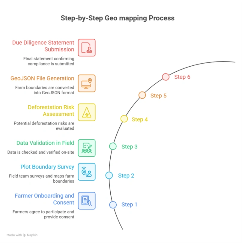
Step-by-Step Geo Mapping Process for Indonesia Palm Oil Exporters
Step 1: Supplier & Plantation Owner Onboarding
Before mapping begins, exporters should:
• Register supplier and plantation owner identity information • Verify land-use rights and cultivation permits • Obtain consent for geolocation collection • Validate legality and plantation documentation • Explain EUDR obligations clearly to suppliers and smallholders
Step 2: Plantation Plot & Boundary Mapping
Field teams use GPS-enabled devices or GIS applications to capture plantation polygons and cultivation boundaries.
Best practices include:
• Confirm GPS accuracy before mapping • Walk actual plantation boundaries • Capture coordinates at regular intervals • Close polygons correctly • Capture geotagged field photographs • Record crop and sourcing details
Step 3: Field-Level Validation
Before leaving the site, field validation should confirm:
• Polygon closure accuracy • No self-intersecting polygons • Area consistency against plantation records • Visual alignment with satellite basemaps
Step 4: Deforestation Risk Assessment
Captured polygons should then be screened against:
• Global Forest Watch • Copernicus datasets • Indonesia forest-cover maps • EU deforestation risk datasets (where applicable)
Plots showing post-2020 deforestation risk may require remediation or exclusion from EU-bound sourcing.
Step 5: GeoJSON File Generation
Validated polygon data must then be exported into:
• RFC 7946-compliant GeoJSON format • Structured geospatial records suitable for DDS workflows • Audit-ready traceability documentation
Proper GeoJSON validation is critical before submission to avoid DDS rejection, customs delays, or shipment disruptions.
Geometry type
Polygon (Feature)
Coordinate system
WGS 84 (EPSG:4326) mandatory
Coordinate order
Longitude first, then Latitude (per GeoJSON spec)
Winding order
Exterior ring: counter-clockwise
Properties
farmer_id, plot_id, area_ha, crop_type, country, region
Encoding
UTF-8
Validation tool
geojsonlint.com, QGIS geometry validator, or Turf.js
Step 6: Due Diligence Statement Submission
The final stage connects GeoJSON polygon data and palm oil traceability records to an official Due Diligence Statement (DDS) submitted through the EU Information System or TRACES-linked workflows.
For Indonesia palm oil exporters, this process typically involves:
• Compiling all validated GeoJSON polygons associated with plantation estates, independent smallholders, cooperatives, mills, and sourcing areas linked to a given export batch.
• Attaching supporting compliance documentation, including plantation permits, land-use approvals, supplier declarations, transport documentation, legality verification records, and deforestation-risk assessment results.
• Completing the DDS workflow while referencing applicable HS codes for palm oil and palm-derived products (for example crude palm oil, refined palm oil, palm kernel oil, oleochemicals, glycerol, fatty alcohols, soaps, surfactants, biodiesel feedstocks, and palm-based derivatives).
• Submitting the DDS through the EU Information System and retaining the generated reference number for customs and shipment documentation.
• Maintaining traceability and compliance records for a minimum of 5 years in accordance with Article 10 of the EU Deforestation Regulation.
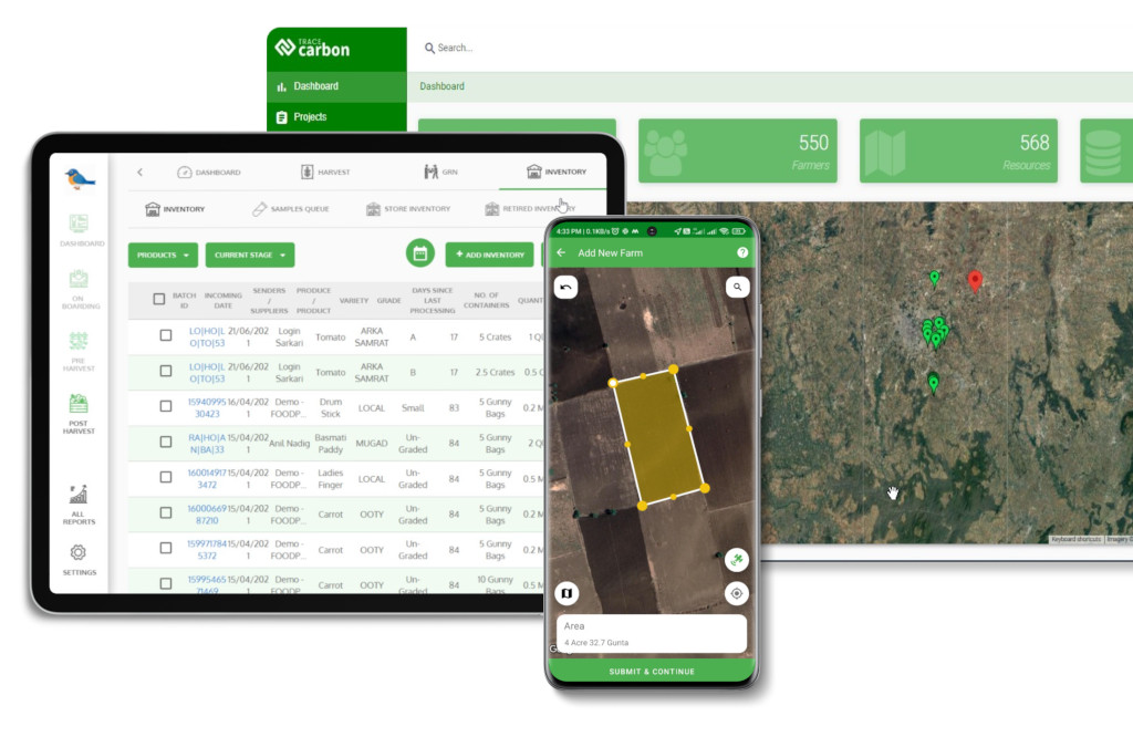
Geo mapping for palm oil exporters in Indonesia becomes significantly easier with TraceX EUDR solutions, enabling accurate plantation mapping, GeoJSON validation, supplier traceability, deforestation risk assessment, mill-level sourcing visibility, and end-to-end DDS compliance management across complex palm oil supply chains.
Common Errors in GeoJSON / Polygon Mapping
Data quality failures at the polygon level are the single most common reason EUDR submissions are flagged for review or rejected. Field teams and data managers should be trained to identify and fix the following errors:
Error Type
Description
Impact
Fix
Self-Intersection
Polygon boundary crosses itself, creating a ‘bowtie’ shape. Occurs when field agent reverses direction while walking.
Latitude and longitude values transposed (lat first, instead of GeoJSON spec’s lon first).
Plot placed in wrong hemisphere or ocean; immediate deforestation false-alarm.
Validate first coordinate: Vietnam lon ≈ 102–109°E; lat ≈ 8–23°N.
Spike Artefacts
One or more vertices are outliers caused by GNSS signal bounce under canopy.
Polygon area inflated; boundary bleeds into adjacent plots.
Remove outlier points; apply Douglas-Peucker simplification at 1m tolerance.
Duplicate Polygons
Same farm submitted twice with different farmer_id due to aggregator duplication.
Inflated area records; compliance review flags double-counting.
Spatial deduplication using PostGIS ST_Equals or Turf.js booleanEqual.
Overly Simplified Polygon
Only 3 or 4 vertices used for complex, irregularly shaped plots.
True boundary not captured; adjacent deforested land may be excluded or included.
Minimum 6–8 vertices for plots with non-linear edges; re-survey if needed.
Conclusion
For Indonesia’s palm oil exporters, EUDR compliance is no longer simply a documentation obligation it represents a major transformation in how palm oil supply chains demonstrate legality, traceability, and deforestation-free sourcing. At the center of that transformation is GPS polygon mapping, which creates the verifiable connection between plantation plots, independent smallholders, mills, and the palm oil products entering the European market.
The challenges are substantial: fragmented supplier ecosystems, smallholder complexity, remote plantation regions, inconsistent land documentation, and geospatial data accuracy all create operational hurdles for exporters. But the direction forward is increasingly clear. Companies that invest early in scalable geo mapping infrastructure combining field-level data collection, GeoJSON validation, deforestation screening, supplier traceability, and DDS automation will not only achieve EUDR readiness, but strengthen long-term competitiveness in global palm oil trade.
The pressure is growing.
Geolocation is now foundational to palm oil compliance.
The companies building these capabilities today will shape the future of sustainable palm oil exports from Indonesia.
Explore the tools you need for EUDR compliance. Discover how wood exporters are using digital solutions for geolocation, traceability, and DDS submission.
What is geo mapping for palm oil exporters in Indonesia?
Geo mapping for palm oil exporters in Indonesia involves capturing GPS polygon coordinates of plantation plots, independent smallholder farms, estates, and sourcing areas to verify palm oil origin and support EUDR deforestation-free sourcing requirements.
Why is geo mapping important for EUDR compliance in palm oil supply chains?
Geo mapping is mandatory under the EU Deforestation Regulation because it enables authorities and buyers to verify that palm oil products are not sourced from land deforested after December 31, 2020.
What data is required for geo mapping palm oil sourcing areas in Indonesia?
Exporters typically need:
• GPS polygon coordinates of plantation plots and sourcing areas • Supplier, plantation owner, and mill information • Palm fruit harvesting and sourcing details • Land-use and legality documentation • Harvest and sourcing records
How do palm oil exporters capture geolocation data for EUDR?
Geolocation data is commonly captured using:
• Mobile GIS applications • GPS-enabled field devices • GeoJSON/KML uploads • Field mapping teams • Satellite-linked mapping platforms
What are the common challenges in geo mapping palm oil supply chains?
Digital traceability solutions help overcome these issues through automated geospatial validation, supplier onboarding, and centralized compliance workflows.
Download the Complete EUDR Checklist for Palm Oil Exporters
Get a practical checklist covering geolocation, traceability, risk assessment, and DDS submission to stay fully compliant.
We use cookies on our website to give you the most relevant experience by remembering your preferences and repeat visits. By clicking “Accept All”, you consent to the use of ALL the cookies. However, you may visit "Cookie Settings" to provide a controlled consent.
This website uses cookies to improve your experience while you navigate through the website. Out of these, the cookies that are categorized as necessary are stored on your browser as they are essential for the working of basic functionalities of the website. We also use third-party cookies that help us analyze and understand how you use this website. These cookies will be stored in your browser only with your consent. You also have the option to opt-out of these cookies. But opting out of some of these cookies may affect your browsing experience.
Necessary cookies are absolutely essential for the website to function properly. These cookies ensure basic functionalities and security features of the website, anonymously.
Cookie
Duration
Description
cookielawinfo-checkbox-analytics
11 months
This cookie is set by GDPR Cookie Consent plugin. The cookie is used to store the user consent for the cookies in the category "Analytics".
cookielawinfo-checkbox-functional
11 months
The cookie is set by GDPR cookie consent to record the user consent for the cookies in the category "Functional".
cookielawinfo-checkbox-necessary
11 months
This cookie is set by GDPR Cookie Consent plugin. The cookies is used to store the user consent for the cookies in the category "Necessary".
cookielawinfo-checkbox-others
11 months
This cookie is set by GDPR Cookie Consent plugin. The cookie is used to store the user consent for the cookies in the category "Other.
cookielawinfo-checkbox-performance
11 months
This cookie is set by GDPR Cookie Consent plugin. The cookie is used to store the user consent for the cookies in the category "Performance".
viewed_cookie_policy
11 months
The cookie is set by the GDPR Cookie Consent plugin and is used to store whether or not user has consented to the use of cookies. It does not store any personal data.
Functional cookies help to perform certain functionalities like sharing the content of the website on social media platforms, collect feedbacks, and other third-party features.
Performance cookies are used to understand and analyze the key performance indexes of the website which helps in delivering a better user experience for the visitors.
Analytical cookies are used to understand how visitors interact with the website. These cookies help provide information on metrics the number of visitors, bounce rate, traffic source, etc.
Advertisement cookies are used to provide visitors with relevant ads and marketing campaigns. These cookies track visitors across websites and collect information to provide customized ads.
Download the 2026 Traceability Scorecard and Benchmark Your Supply Chain Across 10 Critical Capabilities.
Download our eBook
Don’t Wait for an Audit to Find Your EUDR Gaps
The 2026 Simplification Package changes how HS codes, DDS pass-through and geolocation rules apply to you. Get the free guide and 20-point readiness checklist before enforcement catches you unprepared.